Hillersleben geodata
Hillersleben (Saxony-Anhalt) is a populated place; located in Germany in Europe/Berlin (GMT+2) time zone. With population of 824 people, there are 7807 cities with bigger population in this country. Compared to other cities in Germany, 75% of cities are located further ↓South; 74% of cities are located further ←West and 74.7% of cities have higher elevation than Hillersleben. Note1


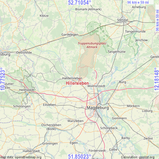
Hillersleben GPS coordinates[2]
52° 16' 56.892" North, 11° 28' 42.06" East
| Map corner | latitude | longitude |
|---|---|---|
| Upper-left | 52.71054°, | 10.77523° |
| Center: | 52.28247°, | 11.47835° |
| Lower-right: | 51.85023°, | 12.18148° |
| Map W x H: | 95.7×95.7 km | = 59.5×59.5mi |
| max Lat: | 55.01917° ⇑25% North |
| Hillersleben: | 52.28247° |
| min Lat: | ⇓75% South 47.40724° |
| min Long | Hillersleben | max Long |
| 5.92978° | 11.47835° | 14.98853° |
| W 74%⇐ | ⇒26% E |
Elevation
Elevation of Hillersleben is 64 m = 210 ft, and this is 185.1 m = 607 ft below average elevation for this country.
| Max E: |
1256 m = 4121 ft | 74.7% |
| Avg. | 249.1 m = 817 ft | |
| Hillersleben | 64 m = 210 ft | |
Min E: |
-5 m = -16 ft | 25.3% |
See also: Germany elevation on elevation.city.
Geographical zone
Hillersleben is located in North temperate zone (between Tropic of Cancer and the Arctic Circle). Distance of this North polar circle is 1587.9 km =986.7 mi to North.| Distance of | km | miles | from Hillersleben |
|---|---|---|---|
| North Pole | 4193.8 | 2605.9 | to North |
| Arctic Circle | 1587.9 | 986.7 | to North |
| Tropic Cancer | 3207.3 | 1992.9 | to South |
| Equator | 5813.3 | 3612.2 | to South |


Nearby cities:
15 places around Hillersleben: (largest is in red/bold)
• Bülstringen
9.5 km =5.9 mi,  293°
293°
• Colbitz
9.5 km =5.9 mi,  65°
65°
• Dahlenwarsleben
10.5 km =6.5 mi,  157°
157°
• Groß Ammensleben
6.3 km =3.9 mi,  151°
151°
• Groß Santersleben
10.2 km =6.3 mi,  188°
188°
• Gutenswegen
5.9 km =3.7 mi,  170°
170°
• Haldensleben I
4.7 km =2.9 mi,  278°
278°
• Jersleben
8.1 km =5 mi,  121°
121°
• Klein Ammensleben
7.7 km =4.8 mi, 158°
• Meitzendorf
9.6 km =6 mi,  143°
143°
• Neuenhofe
2.5 km =1.6 mi,  334°
334°
• Rottmersleben
9.4 km =5.8 mi,  214°
214°
• Samswegen
6.2 km =3.9 mi,  113°
113°
• Schackensleben
10.4 km =6.5 mi,  202°
202°
• Vahldorf
3.2 km =2 mi, 153°
Sources, notices
• [Note1] Compared only with cities in Germany existing in our database
• [Src1] Map data: © OpenStreetMap contributors (CC-BY-SA)
• [Src2] Other city data from geonames.org with taken over terms of usage.
• [Src3] Geographical zone / Annual Mean Temperature by Robert A. Rohde @ Wikipedia
