Uder geodata
Uder (Thuringia) is a seat of a fourth-order administrative division; located in Germany in Europe/Berlin (GMT+2) time zone. With population of 2,509 people, there are 4428 cities with bigger population in this country. Compared to other cities in Germany, 64.2% of cities are located further ↓South; 51.3% of cities are located further ←West and 51.1% of cities have lower elevation than Uder. Note1


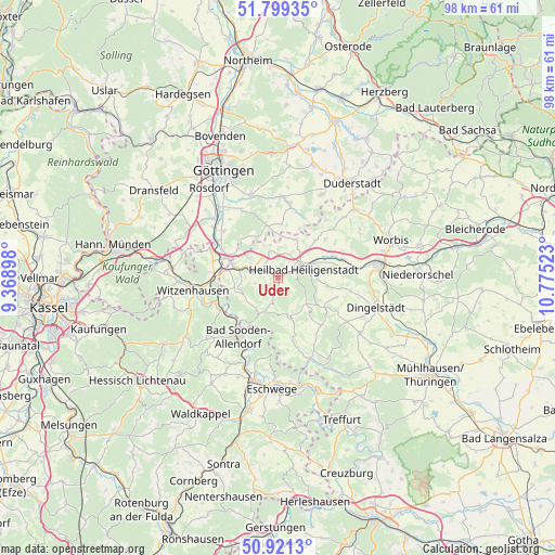
Uder GPS coordinates[2]
51° 21' 44.748" North, 10° 4' 19.56" East
| Map corner | latitude | longitude |
|---|---|---|
| Upper-left | 51.79935°, | 9.36898° |
| Center: | 51.36243°, | 10.0721° |
| Lower-right: | 50.9213°, | 10.77523° |
| Map W x H: | 97.6×97.6 km | = 60.6×60.6mi |
| max Lat: | 55.01917° ⇑35.8% North |
| Uder: | 51.36243° |
| min Lat: | ⇓64.2% South 47.40724° |
| min Long | Uder | max Long |
| 5.92978° | 10.0721° | 14.98853° |
| W 51.3%⇐ | ⇒48.7% E |
Elevation
Elevation of Uder is 234 m = 768 ft, and this is 15.1 m = 50 ft below average elevation for this country.
| Max E: |
1256 m = 4121 ft | 48.9% |
| Avg. | 249.1 m = 817 ft | |
| Uder | 234 m = 768 ft | |
Min E: |
-5 m = -16 ft | 51.1% |
See also: Germany elevation on elevation.city.
Geographical zone
Uder is located in North temperate zone (between Tropic of Cancer and the Arctic Circle). Distance of this North polar circle is 1690.2 km =1050.2 mi to North.| Distance of | km | miles | from Uder |
|---|---|---|---|
| North Pole | 4296.1 | 2669.5 | to North |
| Arctic Circle | 1690.2 | 1050.2 | to North |
| Tropic Cancer | 3105 | 1929.4 | to South |
| Equator | 5711 | 3548.6 | to South |


Nearby cities:
15 places around Uder: (largest is in red/bold)
• Birkenfelde
4.1 km =2.5 mi,  250°
250°
• Burgwalde
2.8 km =1.7 mi,  326°
326°
• Eichstruth
7 km =4.3 mi,  173°
173°
• Freienhagen
6.2 km =3.9 mi,  345°
345°
• Heilbad Heiligenstadt
4.9 km =3 mi,  68°
68°
• Lenterode
3.3 km =2.1 mi,  186°
186°
• Lutter
4.5 km =2.8 mi,  136°
136°
• Marth
5.5 km =3.4 mi,  294°
294°
• Rustenfelde
6.5 km =4 mi,  309°
309°
• Röhrig
4.2 km =2.6 mi,  219°
219°
• Schachtebich
4.5 km =2.8 mi,  339°
339°
• Schönhagen
4.4 km =2.7 mi,  233°
233°
• Steinheuterode
2.4 km =1.5 mi, 350°
• Thalwenden
2.1 km =1.3 mi, 227°
• Wüstheuterode
4.4 km =2.7 mi, 191°
Sources, notices
• [Note1] Compared only with cities in Germany existing in our database
• [Src1] Map data: © OpenStreetMap contributors (CC-BY-SA)
• [Src2] Other city data from geonames.org with taken over terms of usage.
• [Src3] Geographical zone / Annual Mean Temperature by Robert A. Rohde @ Wikipedia
