Schachtebich geodata
Schachtebich (Thuringia) is a seat of a fourth-order administrative division; located in Germany in Europe/Berlin (GMT+2) time zone. With population of 260 people, there are 10208 cities with bigger population in this country. Compared to other cities in Germany, 64.8% of cities are located further ↓South; 50.8% of cities are located further ←West and 57.3% of cities have lower elevation than Schachtebich. Note1


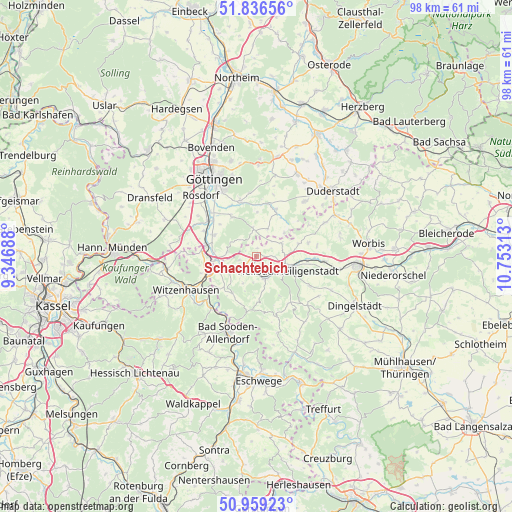
Schachtebich GPS coordinates[2]
51° 24' 0" North, 10° 3' 0" East
| Map corner | latitude | longitude |
|---|---|---|
| Upper-left | 51.83656°, | 9.34688° |
| Center: | 51.4°, | 10.05° |
| Lower-right: | 50.95923°, | 10.75313° |
| Map W x H: | 97.5×97.5 km | = 60.6×60.6mi |
| max Lat: | 55.01917° ⇑35.2% North |
| Schachtebich: | 51.4° |
| min Lat: | ⇓64.8% South 47.40724° |
| min Long | Schachtebich | max Long |
| 5.92978° | 10.05° | 14.98853° |
| W 50.8%⇐ | ⇒49.2% E |
Elevation
Elevation of Schachtebich is 274 m = 899 ft, and this is 24.9 m = 82 ft above average elevation for this country.
| Max E: |
1256 m = 4121 ft | 42.7% |
| Schachtebich | 274 m 899 ft | |
| Avg. | 249.1 m = 817 ft | |
Min E: |
-5 m = -16 ft | 57.3% |
See also: Germany elevation on elevation.city.
Geographical zone
Schachtebich is located in North temperate zone (between Tropic of Cancer and the Arctic Circle). Distance of this North polar circle is 1686 km =1047.6 mi to North.| Distance of | km | miles | from Schachtebich |
|---|---|---|---|
| North Pole | 4291.9 | 2666.9 | to North |
| Arctic Circle | 1686 | 1047.6 | to North |
| Tropic Cancer | 3109.2 | 1932 | to South |
| Equator | 5715.1 | 3551.2 | to South |


Nearby cities:
15 places around Schachtebich: (largest is in red/bold)
• Arenshausen
6.2 km =3.9 mi,  244°
244°
• Birkenfelde
6 km =3.7 mi,  202°
202°
• Burgwalde
1.9 km =1.2 mi,  180°
180°
• Freienhagen
1.9 km =1.2 mi,  0°
0°
• Heilbad Heiligenstadt
6.5 km =4 mi,  111°
111°
• Kirchgandern
6.4 km =4 mi,  254°
254°
• Lenterode
7.5 km =4.7 mi,  171°
171°
• Marth
3.9 km =2.4 mi, 241°
• Rohrberg
3 km =1.9 mi,  308°
308°
• Rustenfelde
3.5 km =2.2 mi,  270°
270°
• Schönhagen
7.1 km =4.4 mi, 196°
• Siemerode
5.5 km =3.4 mi,  62°
62°
• Steinheuterode
2.2 km =1.4 mi,  148°
148°
• Thalwenden
5.6 km =3.5 mi, 180°
• Uder
4.5 km =2.8 mi,  159°
159°
Sources, notices
• [Note1] Compared only with cities in Germany existing in our database
• [Src1] Map data: © OpenStreetMap contributors (CC-BY-SA)
• [Src2] Other city data from geonames.org with taken over terms of usage.
• [Src3] Geographical zone / Annual Mean Temperature by Robert A. Rohde @ Wikipedia
