Schönhagen geodata
Schönhagen (Thuringia) is a seat of a fourth-order administrative division; located in Germany in Europe/Berlin (GMT+2) time zone. With population of 149 people, there are 10697 cities with bigger population in this country. Compared to other cities in Germany, 63.8% of cities are located further ↓South; 50.5% of cities are located further ←West and 66.5% of cities have lower elevation than Schönhagen. Note1


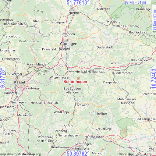
Schönhagen GPS coordinates[2]
51° 20' 20.328" North, 10° 1' 15.24" East
| Map corner | latitude | longitude |
|---|---|---|
| Upper-left | 51.77613°, | 9.31778° |
| Center: | 51.33898°, | 10.0209° |
| Lower-right: | 50.89762°, | 10.72403° |
| Map W x H: | 97.7×97.7 km | = 60.7×60.7mi |
| max Lat: | 55.01917° ⇑36.2% North |
| Schönhagen: | 51.33898° |
| min Lat: | ⇓63.8% South 47.40724° |
| min Long | Schönhagen | max Long |
| 5.92978° | 10.0209° | 14.98853° |
| W 50.5%⇐ | ⇒49.5% E |
Elevation
Elevation of Schönhagen is 332 m = 1089 ft, and this is 82.9 m = 272 ft above average elevation for this country.
| Max E: |
1256 m = 4121 ft | 33.5% |
| Schönhagen | 332 m 1089 ft | |
| Avg. | 249.1 m = 817 ft | |
Min E: |
-5 m = -16 ft | 66.5% |
See also: Germany elevation on elevation.city.
Geographical zone
Schönhagen is located in North temperate zone (between Tropic of Cancer and the Arctic Circle). Distance of this North polar circle is 1692.8 km =1051.9 mi to North.| Distance of | km | miles | from Schönhagen |
|---|---|---|---|
| North Pole | 4298.7 | 2671.1 | to North |
| Arctic Circle | 1692.8 | 1051.9 | to North |
| Tropic Cancer | 3102.4 | 1927.7 | to South |
| Equator | 5708.4 | 3547 | to South |


Nearby cities:
15 places around Schönhagen: (largest is in red/bold)
• Arenshausen
5.5 km =3.4 mi,  318°
318°
• Birkenfelde
1.3 km =0.8 mi,  346°
346°
• Bornhagen
5 km =3.1 mi,  262°
262°
• Burgwalde
5.3 km =3.3 mi,  22°
22°
• Fretterode
2.9 km =1.8 mi,  210°
210°
• Gerbershausen
2.7 km =1.7 mi, 256°
• Lenterode
3.2 km =2 mi,  101°
101°
• Lindewerra
5.5 km =3.4 mi,  243°
243°
• Mackenrode
5.4 km =3.4 mi,  143°
143°
• Marth
5.1 km =3.2 mi,  343°
343°
• Röhrig
1.1 km =0.7 mi,  126°
126°
• Thalwenden
2.4 km =1.5 mi,  58°
58°
• Uder
4.4 km =2.7 mi,  53°
53°
• Wahlhausen
5.1 km =3.2 mi, 211°
• Wüstheuterode
3.2 km =2 mi,  123°
123°
Sources, notices
• [Note1] Compared only with cities in Germany existing in our database
• [Src1] Map data: © OpenStreetMap contributors (CC-BY-SA)
• [Src2] Other city data from geonames.org with taken over terms of usage.
• [Src3] Geographical zone / Annual Mean Temperature by Robert A. Rohde @ Wikipedia
