Trennewurth geodata
Trennewurth (Schleswig-Holstein) is a seat of a fourth-order administrative division; located in Germany in Europe/Berlin (GMT+2) time zone. With population of 294 people, there are 10077 cities with bigger population in this country. Compared to other cities in Germany, 92.6% of cities are located further ↓South; 65% of cities are located further →East and 98.6% of cities have higher elevation than Trennewurth. Note1
Administrative division(s):
- Level 1: Schleswig-Holstein
- Level 3: Kreis Dithmarschen
- Level 4: Trennewurth


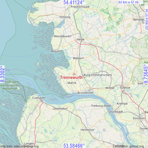
Trennewurth GPS coordinates[2]
54° 0' 0" North, 9° 1' 59.988" East
| Map corner | latitude | longitude |
|---|---|---|
| Upper-left | 54.41124°, | 8.3302° |
| Center: | 54°, | 9.03333° |
| Lower-right: | 53.58466°, | 9.73645° |
| Map W x H: | 91.9×91.9 km | = 57.1×57.1mi |
| max Lat: | 55.01917° ⇑7.4% North |
| Trennewurth: | 54° |
| min Lat: | ⇓92.6% South 47.40724° |
| min Long | Trennewurth | max Long |
| 5.92978° | 9.03333° | 14.98853° |
| W 35%⇐ | ⇒65% E |
Elevation
Elevation of Trennewurth is 1 m = 3 ft, and this is 248.1 m = 814 ft below average elevation for this country.
| Max E: |
1256 m = 4121 ft | 98.6% |
| Avg. | 249.1 m = 817 ft | |
| Trennewurth | 1 m = 3 ft | |
Min E: |
-5 m = -16 ft | 1.4% |
See also: Germany elevation on elevation.city.
Geographical zone
Trennewurth is located in North temperate zone (between Tropic of Cancer and the Arctic Circle). Distance of this North polar circle is 1396.9 km =868 mi to North.| Distance of | km | miles | from Trennewurth |
|---|---|---|---|
| North Pole | 4002.8 | 2487.2 | to North |
| Arctic Circle | 1396.9 | 868 | to North |
| Tropic Cancer | 3398.3 | 2111.6 | to South |
| Equator | 6004.2 | 3730.8 | to South |


Nearby cities:
15 places around Trennewurth: (largest is in red/bold)
• Barlt
2.1 km =1.3 mi,  30°
30°
• Busenwurth
4.6 km =2.9 mi,  3°
3°
• Diekhusen-Fahrstedt
7.5 km =4.7 mi,  188°
188°
• Dingen
6.6 km =4.1 mi,  124°
124°
• Eddelak
9.4 km =5.8 mi,  126°
126°
• Elpersbüttel
8.1 km =5 mi,  6°
6°
• Friedrichskoog
7.8 km =4.8 mi,  283°
283°
• Gudendorf
5.6 km =3.5 mi,  61°
61°
• Helse
3.2 km =2 mi,  207°
207°
• Kronprinzenkoog
5.7 km =3.5 mi,  229°
229°
• Marnerdeich
6.4 km =4 mi, 210°
• Ramhusen
6.4 km =4 mi,  149°
149°
• Sankt Michaelisdonn
5.8 km =3.6 mi,  108°
108°
• Schmedeswurth
9.3 km =5.8 mi,  173°
173°
• Windbergen
7.8 km =4.8 mi,  44°
44°
Sources, notices
• [Note1] Compared only with cities in Germany existing in our database
• [Src1] Map data: © OpenStreetMap contributors (CC-BY-SA)
• [Src2] Other city data from geonames.org with taken over terms of usage.
• [Src3] Geographical zone / Annual Mean Temperature by Robert A. Rohde @ Wikipedia
