Elpersbüttel geodata
Elpersbüttel (Schleswig-Holstein) is a seat of a fourth-order administrative division; located in Germany in Europe/Berlin (GMT+2) time zone. With population of 907 people, there are 7500 cities with bigger population in this country. Compared to other cities in Germany, 93.5% of cities are located further ↓South; 64.8% of cities are located further →East and 98.6% of cities have higher elevation than Elpersbüttel. Note1
Administrative division(s):
- Level 1: Schleswig-Holstein
- Level 3: Kreis Dithmarschen
- Level 4: Elpersbüttel


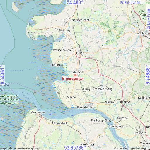
Elpersbüttel GPS coordinates[2]
54° 4' 20.928" North, 9° 2' 48.228" East
| Map corner | latitude | longitude |
|---|---|---|
| Upper-left | 54.483°, | 8.34361° |
| Center: | 54.07248°, | 9.04673° |
| Lower-right: | 53.65786°, | 9.74986° |
| Map W x H: | 91.7×91.7 km | = 57×57mi |
| max Lat: | 55.01917° ⇑6.5% North |
| Elpersbüttel: | 54.07248° |
| min Lat: | ⇓93.5% South 47.40724° |
| min Long | Elpersbüttel | max Long |
| 5.92978° | 9.04673° | 14.98853° |
| W 35.2%⇐ | ⇒64.8% E |
Elevation
Elevation of Elpersbüttel is 1 m = 3 ft, and this is 248.1 m = 814 ft below average elevation for this country.
| Max E: |
1256 m = 4121 ft | 98.6% |
| Avg. | 249.1 m = 817 ft | |
| Elpersbüttel | 1 m = 3 ft | |
Min E: |
-5 m = -16 ft | 1.4% |
See also: Germany elevation on elevation.city.
Geographical zone
Elpersbüttel is located in North temperate zone (between Tropic of Cancer and the Arctic Circle). Distance of this North polar circle is 1388.9 km =863 mi to North.| Distance of | km | miles | from Elpersbüttel |
|---|---|---|---|
| North Pole | 3994.8 | 2482.3 | to North |
| Arctic Circle | 1388.9 | 863 | to North |
| Tropic Cancer | 3406.4 | 2116.6 | to South |
| Equator | 6012.3 | 3735.9 | to South |


Nearby cities:
15 places around Elpersbüttel: (largest is in red/bold)
• Bargenstedt
7.4 km =4.6 mi,  65°
65°
• Barlt
6.2 km =3.9 mi,  178°
178°
• Busenwurth
3.5 km =2.2 mi,  189°
189°
• Epenwöhrden
4.2 km =2.6 mi,  5°
5°
• Frestedt
9.9 km =6.2 mi,  116°
116°
• Gudendorf
6.7 km =4.2 mi,  143°
143°
• Hemmingstedt
8.7 km =5.4 mi, 8°
• Krumstedt
8.9 km =5.5 mi,  94°
94°
• Lieth
9.3 km =5.8 mi, 5°
• Meldorf
2.6 km =1.6 mi,  33°
33°
• Nindorf
4.7 km =2.9 mi,  75°
75°
• Sarzbüttel
10.2 km =6.3 mi,  61°
61°
• Trennewurth
8.1 km =5 mi, 186°
• Windbergen
5.2 km =3.2 mi, 118°
• Wolmersdorf
3.7 km =2.3 mi, 82°
Sources, notices
• [Note1] Compared only with cities in Germany existing in our database
• [Src1] Map data: © OpenStreetMap contributors (CC-BY-SA)
• [Src2] Other city data from geonames.org with taken over terms of usage.
• [Src3] Geographical zone / Annual Mean Temperature by Robert A. Rohde @ Wikipedia
