Eddelak geodata
Eddelak (Schleswig-Holstein) is a seat of a fourth-order administrative division; located in Germany in Europe/Berlin (GMT+2) time zone. With population of 1,455 people, there are 5970 cities with bigger population in this country. Compared to other cities in Germany, 92% of cities are located further ↓South; 63.3% of cities are located further →East and 99.5% of cities have higher elevation than Eddelak. Note1
Administrative division(s):
- Level 1: Schleswig-Holstein
- Level 3: Kreis Dithmarschen
- Level 4: Eddelak


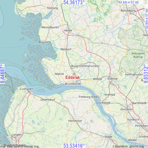
Eddelak GPS coordinates[2]
53° 57' 0" North, 9° 9' 0" East
| Map corner | latitude | longitude |
|---|---|---|
| Upper-left | 54.36173°, | 8.44687° |
| Center: | 53.95°, | 9.15° |
| Lower-right: | 53.53416°, | 9.85312° |
| Map W x H: | 92×92 km | = 57.2×57.2mi |
| max Lat: | 55.01917° ⇑8% North |
| Eddelak: | 53.95° |
| min Lat: | ⇓92% South 47.40724° |
| min Long | Eddelak | max Long |
| 5.92978° | 9.15° | 14.98853° |
| W 36.7%⇐ | ⇒63.3% E |
Elevation
Elevation of Eddelak is -1 m = -3 ft, and this is 250.1 m = 821 ft below average elevation for this country.
| Max E: |
1256 m = 4121 ft | 99.5% |
| Avg. | 249.1 m = 817 ft | |
| Eddelak | -1 m = -3 ft | |
Min E: |
-5 m = -16 ft | 0.5% |
See also: Germany elevation on elevation.city.
Geographical zone
Eddelak is located in North temperate zone (between Tropic of Cancer and the Arctic Circle). Distance of this North polar circle is 1402.5 km =871.5 mi to North.| Distance of | km | miles | from Eddelak |
|---|---|---|---|
| North Pole | 4008.4 | 2490.7 | to North |
| Arctic Circle | 1402.5 | 871.5 | to North |
| Tropic Cancer | 3392.8 | 2108.2 | to South |
| Equator | 5998.7 | 3727.4 | to South |


Nearby cities:
15 places around Eddelak: (largest is in red/bold)
• Averlak
2.5 km =1.6 mi,  116°
116°
• Brunsbüttel
6.8 km =4.2 mi,  205°
205°
• Buchholz
6.4 km =4 mi,  48°
48°
• Burg
8.8 km =5.5 mi, 53°
• Büttel
7.8 km =4.8 mi,  135°
135°
• Dingen
2.9 km =1.8 mi,  310°
310°
• Ecklak
7.6 km =4.7 mi,  90°
90°
• Gudendorf
8.7 km =5.4 mi,  341°
341°
• Kuden
2.9 km =1.8 mi, 49°
• Kudensee
4.7 km =2.9 mi,  113°
113°
• Landscheide
7.5 km =4.7 mi, 116°
• Quickborn
7.8 km =4.8 mi,  29°
29°
• Ramhusen
4.4 km =2.7 mi,  270°
270°
• Sankt Michaelisdonn
4.3 km =2.7 mi,  329°
329°
• Schmedeswurth
7.5 km =4.7 mi,  240°
240°
Sources, notices
• [Note1] Compared only with cities in Germany existing in our database
• [Src1] Map data: © OpenStreetMap contributors (CC-BY-SA)
• [Src2] Other city data from geonames.org with taken over terms of usage.
• [Src3] Geographical zone / Annual Mean Temperature by Robert A. Rohde @ Wikipedia
