Thomm geodata
Thomm (Rheinland-Pfalz) is a seat of a fourth-order administrative division; located in Germany in Europe/Berlin (GMT+2) time zone. With population of 1,036 people, there are 7066 cities with bigger population in this country. Compared to other cities in Germany, 70.4% of cities are located further ↑North; 95.5% of cities are located further →East and 84.4% of cities have lower elevation than Thomm. Note1
Administrative division(s):
- Level 1: Rheinland-Pfalz
- Level 3: Landkreis Trier-Saarburg
- Level 4: Thomm


Thomm GPS coordinates[2]
49° 44' 29.04" North, 6° 48' 17.712" East
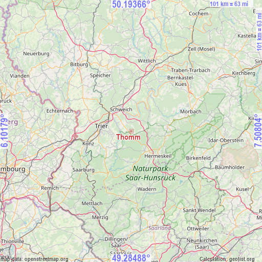
| Map corner | latitude | longitude |
|---|---|---|
| Upper-left | 50.19366°, | 6.10179° |
| Center: | 49.7414°, | 6.80492° |
| Lower-right: | 49.28488°, | 7.50804° |
| Map W x H: | 101×101 km | = 62.8×62.8mi |
| max Lat: | 55.01917° ⇑70.4% North |
| Thomm: | 49.7414° |
| min Lat: | ⇓29.6% South 47.40724° |
| min Long | Thomm | max Long |
| 5.92978° | 6.80492° | 14.98853° |
| W 4.5%⇐ | ⇒95.5% E |
Elevation
Elevation of Thomm is 464 m = 1522 ft, and this is 214.9 m = 705 ft above average elevation for this country.
| Max E: |
1256 m = 4121 ft | 15.6% |
| Thomm | 464 m 1522 ft | |
| Avg. | 249.1 m = 817 ft | |
Min E: |
-5 m = -16 ft | 84.4% |
See also: Germany elevation on elevation.city.
Geographical zone
Thomm is located in North temperate zone (between Tropic of Cancer and the Arctic Circle). Distance of this North polar circle is 1870.4 km =1162.2 mi to North.| Distance of | km | miles | from Thomm |
|---|---|---|---|
| North Pole | 4476.3 | 2781.4 | to North |
| Arctic Circle | 1870.4 | 1162.2 | to North |
| Tropic Cancer | 2924.8 | 1817.4 | to South |
| Equator | 5530.7 | 3436.6 | to South |


Nearby cities:
15 places around Thomm: (largest is in red/bold)
• Bescheid
5.7 km =3.5 mi,  80°
80°
• Farschweiler
2.9 km =1.8 mi,  162°
162°
• Fell
3.2 km =2 mi,  331°
331°
• Gutweiler
5.8 km =3.6 mi,  241°
241°
• Herl
1.2 km =0.7 mi,  136°
136°
• Kasel
5.7 km =3.5 mi,  293°
293°
• Korlingen
6 km =3.7 mi,  254°
254°
• Lorscheid
3.4 km =2.1 mi,  105°
105°
• Mertesdorf
6.2 km =3.9 mi,  303°
303°
• Morscheid
4 km =2.5 mi,  257°
257°
• Osburg
3.2 km =2 mi,  209°
209°
• Riol
5.8 km =3.6 mi,  350°
350°
• Riveris
3.9 km =2.4 mi,  224°
224°
• Sommerau
5.8 km =3.6 mi, 241°
• Waldrach
4.3 km =2.7 mi,  277°
277°
Sources, notices
• [Note1] Compared only with cities in Germany existing in our database
• [Src1] Map data: © OpenStreetMap contributors (CC-BY-SA)
• [Src2] Other city data from geonames.org with taken over terms of usage.
• [Src3] Geographical zone / Annual Mean Temperature by Robert A. Rohde @ Wikipedia
