Boksee geodata
Boksee (Schleswig-Holstein) is a seat of a fourth-order administrative division; located in Germany in Europe/Berlin (GMT+2) time zone. With population of 466 people, there are 9484 cities with bigger population in this country. Compared to other cities in Germany, 95.5% of cities are located further ↓South; 52.2% of cities are located further ←West and 80.2% of cities have higher elevation than Boksee. Note1


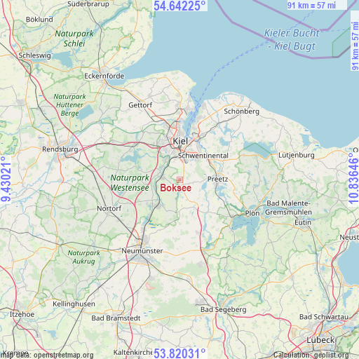
Boksee GPS coordinates[2]
54° 13' 59.988" North, 10° 7' 59.988" East
| Map corner | latitude | longitude |
|---|---|---|
| Upper-left | 54.64225°, | 9.43021° |
| Center: | 54.23333°, | 10.13333° |
| Lower-right: | 53.82031°, | 10.83646° |
| Map W x H: | 91.4×91.4 km | = 56.8×56.8mi |
| max Lat: | 55.01917° ⇑4.5% North |
| Boksee: | 54.23333° |
| min Lat: | ⇓95.5% South 47.40724° |
| min Long | Boksee | max Long |
| 5.92978° | 10.13333° | 14.98853° |
| W 52.2%⇐ | ⇒47.8% E |
Elevation
Elevation of Boksee is 46 m = 151 ft, and this is 203.1 m = 666 ft below average elevation for this country.
| Max E: |
1256 m = 4121 ft | 80.2% |
| Avg. | 249.1 m = 817 ft | |
| Boksee | 46 m = 151 ft | |
Min E: |
-5 m = -16 ft | 19.8% |
See also: Germany elevation on elevation.city.
Geographical zone
Boksee is located in North temperate zone (between Tropic of Cancer and the Arctic Circle). Distance of this North polar circle is 1371 km =851.9 mi to North.| Distance of | km | miles | from Boksee |
|---|---|---|---|
| North Pole | 3976.9 | 2471.1 | to North |
| Arctic Circle | 1371 | 851.9 | to North |
| Tropic Cancer | 3424.3 | 2127.8 | to South |
| Equator | 6030.2 | 3747 | to South |


Nearby cities:
15 places around Boksee: (largest is in red/bold)
• Barmissen
4.9 km =3 mi,  138°
138°
• Bissee
5.7 km =3.5 mi,  191°
191°
• Bothkamp
3.7 km =2.3 mi,  180°
180°
• Böhnhusen
4.7 km =2.9 mi,  246°
246°
• Flintbek
4.7 km =2.9 mi,  293°
293°
• Großbarkau
2.2 km =1.4 mi,  90°
90°
• Honigsee
3.2 km =2 mi, 90°
• Kirchbarkau
2.6 km =1.6 mi,  164°
164°
• Klein Barkau
0 km =0 mi,  0°
0°
• Molfsee
5.7 km =3.5 mi,  310°
310°
• Nettelsee
7.4 km =4.6 mi,  148°
148°
• Pohnsdorf
7.5 km =4.7 mi,  84°
84°
• Postfeld
5.8 km =3.6 mi,  116°
116°
• Techelsdorf
5.7 km =3.5 mi, 251°
• Warnau
6 km =3.7 mi, 158°
Sources, notices
• [Note1] Compared only with cities in Germany existing in our database
• [Src1] Map data: © OpenStreetMap contributors (CC-BY-SA)
• [Src2] Other city data from geonames.org with taken over terms of usage.
• [Src3] Geographical zone / Annual Mean Temperature by Robert A. Rohde @ Wikipedia
