Tarp geodata
Tarp (Schleswig-Holstein) is a seat of a fourth-order administrative division; located in Germany in Europe/Berlin (GMT+2) time zone. With population of 5,711 people, there are 2558 cities with bigger population in this country. Compared to other cities in Germany, 99% of cities are located further ↓South; 59.3% of cities are located further →East and 88% of cities have higher elevation than Tarp. Note1
Administrative division(s):
- Level 1: Schleswig-Holstein
- Level 3: Kreis Schleswig-Flensburg
- Level 4: Tarp


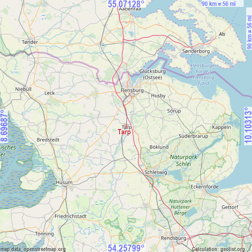
Tarp GPS coordinates[2]
54° 40' 0.012" North, 9° 24' 0" East
| Map corner | latitude | longitude |
|---|---|---|
| Upper-left | 55.07128°, | 8.69687° |
| Center: | 54.66667°, | 9.4° |
| Lower-right: | 54.25799°, | 10.10313° |
| Map W x H: | 90.4×90.4 km | = 56.2×56.2mi |
| max Lat: | 55.01917° ⇑1% North |
| Tarp: | 54.66667° |
| min Lat: | ⇓99% South 47.40724° |
| min Long | Tarp | max Long |
| 5.92978° | 9.4° | 14.98853° |
| W 40.7%⇐ | ⇒59.3% E |
Elevation
Elevation of Tarp is 27 m = 89 ft, and this is 222.1 m = 729 ft below average elevation for this country.
| Max E: |
1256 m = 4121 ft | 88% |
| Avg. | 249.1 m = 817 ft | |
| Tarp | 27 m = 89 ft | |
Min E: |
-5 m = -16 ft | 12% |
See also: Germany elevation on elevation.city.
Geographical zone
Tarp is located in North temperate zone (between Tropic of Cancer and the Arctic Circle). Distance of this North polar circle is 1322.8 km =821.9 mi to North.| Distance of | km | miles | from Tarp |
|---|---|---|---|
| North Pole | 3928.7 | 2441.2 | to North |
| Arctic Circle | 1322.8 | 821.9 | to North |
| Tropic Cancer | 3472.4 | 2157.6 | to South |
| Equator | 6078.4 | 3776.9 | to South |


Nearby cities:
15 places around Tarp: (largest is in red/bold)
• Bollingstedt
8.3 km =5.2 mi,  172°
172°
• Eggebek
6 km =3.7 mi,  201°
201°
• Freienwill
9.1 km =5.7 mi,  41°
41°
• Großsolt
8.4 km =5.2 mi,  63°
63°
• Havetoft
7.7 km =4.8 mi,  103°
103°
• Havetoftloit
10.3 km =6.4 mi,  93°
93°
• Janneby
7.4 km =4.6 mi,  240°
240°
• Jarplund-Weding
7.9 km =4.9 mi,  8°
8°
• Jerrishoe
2.3 km =1.4 mi, 240°
• Jörl
9.8 km =6.1 mi,  220°
220°
• Langstedt
5.7 km =3.5 mi,  190°
190°
• Oeversee
4.3 km =2.7 mi,  30°
30°
• Sankelmark
5.9 km =3.7 mi, 14°
• Sieverstedt
5.3 km =3.3 mi,  122°
122°
• Wanderup
4.7 km =2.9 mi,  293°
293°
Sources, notices
• [Note1] Compared only with cities in Germany existing in our database
• [Src1] Map data: © OpenStreetMap contributors (CC-BY-SA)
• [Src2] Other city data from geonames.org with taken over terms of usage.
• [Src3] Geographical zone / Annual Mean Temperature by Robert A. Rohde @ Wikipedia
