Sieverstedt geodata
Sieverstedt (Schleswig-Holstein) is a seat of a fourth-order administrative division; located in Germany in Europe/Berlin (GMT+2) time zone. With population of 1,653 people, there are 5596 cities with bigger population in this country. Compared to other cities in Germany, 98.9% of cities are located further ↓South; 58.3% of cities are located further →East and 87.7% of cities have higher elevation than Sieverstedt. Note1
Administrative division(s):
- Level 1: Schleswig-Holstein
- Level 3: Kreis Schleswig-Flensburg
- Level 4: Sieverstedt


Sieverstedt GPS coordinates[2]
54° 38' 29.22" North, 9° 28' 10.164" East
| Map corner | latitude | longitude |
|---|---|---|
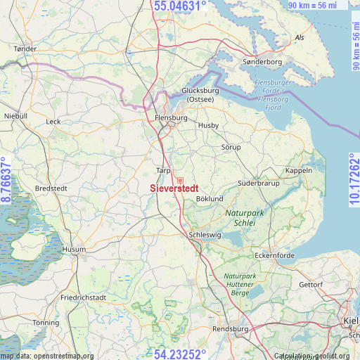
| Upper-left | 55.04631°, | 8.76637° |
| Center: | 54.64145°, | 9.46949° |
| Lower-right: | 54.23252°, | 10.17262° |
| Map W x H: | 90.5×90.5 km | = 56.2×56.2mi |
| max Lat: | 55.01917° ⇑1.1% North |
| Sieverstedt: | 54.64145° |
| min Lat: | ⇓98.9% South 47.40724° |
| min Long | Sieverstedt | max Long |
| 5.92978° | 9.46949° | 14.98853° |
| W 41.7%⇐ | ⇒58.3% E |
Elevation
Elevation of Sieverstedt is 28 m = 92 ft, and this is 221.1 m = 725 ft below average elevation for this country.
| Max E: |
1256 m = 4121 ft | 87.7% |
| Avg. | 249.1 m = 817 ft | |
| Sieverstedt | 28 m = 92 ft | |
Min E: |
-5 m = -16 ft | 12.3% |
See also: Germany elevation on elevation.city.
Geographical zone
Sieverstedt is located in North temperate zone (between Tropic of Cancer and the Arctic Circle). Distance of this North polar circle is 1325.6 km =823.7 mi to North.| Distance of | km | miles | from Sieverstedt |
|---|---|---|---|
| North Pole | 3931.5 | 2442.9 | to North |
| Arctic Circle | 1325.6 | 823.7 | to North |
| Tropic Cancer | 3469.6 | 2155.9 | to South |
| Equator | 6075.6 | 3775.2 | to South |


Nearby cities:
15 places around Sieverstedt: (largest is in red/bold)
• Bollingstedt
6.4 km =4 mi,  211°
211°
• Böklund
8.7 km =5.4 mi,  122°
122°
• Eggebek
7.2 km =4.5 mi,  247°
247°
• Großsolt
7.2 km =4.5 mi,  24°
24°
• Havetoft
3.2 km =2 mi,  72°
72°
• Havetoftloit
6.2 km =3.9 mi, 68°
• Idstedt
7.1 km =4.4 mi,  154°
154°
• Jerrishoe
6.7 km =4.2 mi,  284°
284°
• Klappholz
5.9 km =3.7 mi, 117°
• Langstedt
6.2 km =3.9 mi,  243°
243°
• Oeversee
6.9 km =4.3 mi,  340°
340°
• Sankelmark
9 km =5.6 mi, 340°
• Stolk
6.9 km =4.3 mi,  131°
131°
• Tarp
5.3 km =3.3 mi,  302°
302°
• Ülsby
8.4 km =5.2 mi,  96°
96°
Sources, notices
• [Note1] Compared only with cities in Germany existing in our database
• [Src1] Map data: © OpenStreetMap contributors (CC-BY-SA)
• [Src2] Other city data from geonames.org with taken over terms of usage.
• [Src3] Geographical zone / Annual Mean Temperature by Robert A. Rohde @ Wikipedia
