Sankelmark geodata
Sankelmark (Schleswig-Holstein) is a populated place; located in Germany in Europe/Berlin (GMT+2) time zone. With population of 1,358 people, there are 6164 cities with bigger population in this country. Compared to other cities in Germany, 99.3% of cities are located further ↓South; 58.9% of cities are located further →East and 84.5% of cities have higher elevation than Sankelmark. Note1
Administrative division(s):
- Level 1: Schleswig-Holstein
- Level 3: Kreis Schleswig-Flensburg
- Level 4: Oeversee


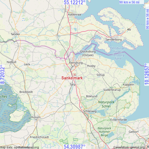
Sankelmark GPS coordinates[2]
54° 43' 4.908" North, 9° 25' 24.384" East
| Map corner | latitude | longitude |
|---|---|---|
| Upper-left | 55.12212°, | 8.72032° |
| Center: | 54.71803°, | 9.42344° |
| Lower-right: | 54.30987°, | 10.12657° |
| Map W x H: | 90.3×90.3 km | = 56.1×56.1mi |
| max Lat: | 55.01917° ⇑0.7% North |
| Sankelmark: | 54.71803° |
| min Lat: | ⇓99.3% South 47.40724° |
| min Long | Sankelmark | max Long |
| 5.92978° | 9.42344° | 14.98853° |
| W 41.1%⇐ | ⇒58.9% E |
Elevation
Elevation of Sankelmark is 36 m = 118 ft, and this is 213.1 m = 699 ft below average elevation for this country.
| Max E: |
1256 m = 4121 ft | 84.5% |
| Avg. | 249.1 m = 817 ft | |
| Sankelmark | 36 m = 118 ft | |
Min E: |
-5 m = -16 ft | 15.5% |
See also: Germany elevation on elevation.city.
Geographical zone
Sankelmark is located in North temperate zone (between Tropic of Cancer and the Arctic Circle). Distance of this North polar circle is 1317.1 km =818.4 mi to North.| Distance of | km | miles | from Sankelmark |
|---|---|---|---|
| North Pole | 3923 | 2437.6 | to North |
| Arctic Circle | 1317.1 | 818.4 | to North |
| Tropic Cancer | 3478.2 | 2161.3 | to South |
| Equator | 6084.1 | 3780.5 | to South |


Nearby cities:
15 places around Sankelmark: (largest is in red/bold)
• Ausacker
9.4 km =5.8 mi,  79°
79°
• Flensburg
7.4 km =4.6 mi,  8°
8°
• Freienwill
4.7 km =2.9 mi, 76°
• Großsolt
6.3 km =3.9 mi,  108°
108°
• Handewitt
7.9 km =4.9 mi,  313°
313°
• Harrislee
9.5 km =5.9 mi,  344°
344°
• Hürup
7.9 km =4.9 mi,  63°
63°
• Jarplund-Weding
2.2 km =1.4 mi,  350°
350°
• Jerrishoe
7.7 km =4.8 mi,  207°
207°
• Maasbüll
9.2 km =5.7 mi,  44°
44°
• Oeversee
2.1 km =1.3 mi,  162°
162°
• Sieverstedt
9 km =5.6 mi, 160°
• Tarp
5.9 km =3.7 mi,  194°
194°
• Tastrup
6.6 km =4.1 mi, 35°
• Wanderup
7 km =4.3 mi,  236°
236°
Sources, notices
• [Note1] Compared only with cities in Germany existing in our database
• [Src1] Map data: © OpenStreetMap contributors (CC-BY-SA)
• [Src2] Other city data from geonames.org with taken over terms of usage.
• [Src3] Geographical zone / Annual Mean Temperature by Robert A. Rohde @ Wikipedia
