Tackesdorf geodata
Tackesdorf (Schleswig-Holstein) is a seat of a fourth-order administrative division; located in Germany in Europe/Berlin (GMT+2) time zone. With population of 91 people, there are 10869 cities with bigger population in this country. Compared to other cities in Germany, 94.9% of cities are located further ↓South; 58% of cities are located further →East and 96.2% of cities have higher elevation than Tackesdorf. Note1
Administrative division(s):
- Level 1: Schleswig-Holstein
- Level 3: Kreis Rendsburg-Eckernförde
- Level 4: Tackesdorf


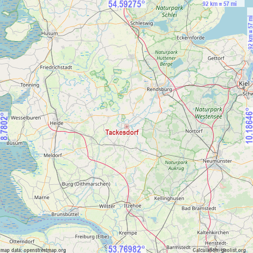
Tackesdorf GPS coordinates[2]
54° 10' 59.988" North, 9° 28' 59.988" East
| Map corner | latitude | longitude |
|---|---|---|
| Upper-left | 54.59275°, | 8.7802° |
| Center: | 54.18333°, | 9.48333° |
| Lower-right: | 53.76982°, | 10.18646° |
| Map W x H: | 91.5×91.5 km | = 56.9×56.9mi |
| max Lat: | 55.01917° ⇑5.1% North |
| Tackesdorf: | 54.18333° |
| min Lat: | ⇓94.9% South 47.40724° |
| min Long | Tackesdorf | max Long |
| 5.92978° | 9.48333° | 14.98853° |
| W 42%⇐ | ⇒58% E |
Elevation
Elevation of Tackesdorf is 6 m = 20 ft, and this is 243.1 m = 798 ft below average elevation for this country.
| Max E: |
1256 m = 4121 ft | 96.2% |
| Avg. | 249.1 m = 817 ft | |
| Tackesdorf | 6 m = 20 ft | |
Min E: |
-5 m = -16 ft | 3.8% |
See also: Germany elevation on elevation.city.
Geographical zone
Tackesdorf is located in North temperate zone (between Tropic of Cancer and the Arctic Circle). Distance of this North polar circle is 1376.6 km =855.4 mi to North.| Distance of | km | miles | from Tackesdorf |
|---|---|---|---|
| North Pole | 3982.4 | 2474.5 | to North |
| Arctic Circle | 1376.6 | 855.4 | to North |
| Tropic Cancer | 3418.7 | 2124.3 | to South |
| Equator | 6024.6 | 3743.5 | to South |


Nearby cities:
15 places around Tackesdorf: (largest is in red/bold)
• Beringstedt
8.1 km =5 mi,  156°
156°
• Breiholz
3.6 km =2.2 mi,  46°
46°
• Embühren
6.8 km =4.2 mi,  105°
105°
• Gokels
7.5 km =4.7 mi,  188°
188°
• Haale
4.3 km =2.7 mi,  90°
90°
• Hamdorf
5.2 km =3.2 mi,  26°
26°
• Hanerau-Hademarschen
7.1 km =4.4 mi,  217°
217°
• Hörsten
8.6 km =5.3 mi, 49°
• Lütjenwestedt
5.6 km =3.5 mi,  180°
180°
• Offenbüttel
8.5 km =5.3 mi,  260°
260°
• Oldenbüttel
2.9 km =1.8 mi,  229°
229°
• Prinzenmoor
4.3 km =2.7 mi,  329°
329°
• Steenfeld
8.4 km =5.2 mi,  243°
243°
• Todenbüttel
7.1 km =4.4 mi,  142°
142°
• Wrohm
7.4 km =4.6 mi,  296°
296°
Sources, notices
• [Note1] Compared only with cities in Germany existing in our database
• [Src1] Map data: © OpenStreetMap contributors (CC-BY-SA)
• [Src2] Other city data from geonames.org with taken over terms of usage.
• [Src3] Geographical zone / Annual Mean Temperature by Robert A. Rohde @ Wikipedia
