Sustrum geodata
Sustrum (Lower Saxony) is a seat of a fourth-order administrative division; located in Germany in Europe/Berlin (GMT+2) time zone. With population of 1,258 people, there are 6420 cities with bigger population in this country. Compared to other cities in Germany, 81.2% of cities are located further ↓South; 90.3% of cities are located further →East and 96.2% of cities have higher elevation than Sustrum. Note1


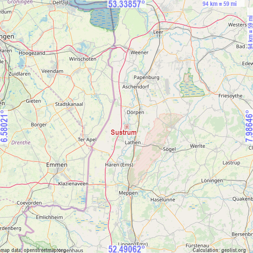
Sustrum GPS coordinates[2]
52° 55' 0.012" North, 7° 16' 59.988" East
| Map corner | latitude | longitude |
|---|---|---|
| Upper-left | 53.33857°, | 6.58021° |
| Center: | 52.91667°, | 7.28333° |
| Lower-right: | 52.49062°, | 7.98646° |
| Map W x H: | 94.3×94.3 km | = 58.6×58.6mi |
| max Lat: | 55.01917° ⇑18.8% North |
| Sustrum: | 52.91667° |
| min Lat: | ⇓81.2% South 47.40724° |
| min Long | Sustrum | max Long |
| 5.92978° | 7.28333° | 14.98853° |
| W 9.7%⇐ | ⇒90.3% E |
Elevation
Elevation of Sustrum is 6 m = 20 ft, and this is 243.1 m = 798 ft below average elevation for this country.
| Max E: |
1256 m = 4121 ft | 96.2% |
| Avg. | 249.1 m = 817 ft | |
| Sustrum | 6 m = 20 ft | |
Min E: |
-5 m = -16 ft | 3.8% |
See also: Germany elevation on elevation.city.
Geographical zone
Sustrum is located in North temperate zone (between Tropic of Cancer and the Arctic Circle). Distance of this North polar circle is 1517.4 km =942.9 mi to North.| Distance of | km | miles | from Sustrum |
|---|---|---|---|
| North Pole | 4123.3 | 2562.1 | to North |
| Arctic Circle | 1517.4 | 942.9 | to North |
| Tropic Cancer | 3277.9 | 2036.8 | to South |
| Equator | 5883.8 | 3656 | to South |


Nearby cities:
15 places around Sustrum: (largest is in red/bold)
• Dersum
5 km =3.1 mi,  352°
352°
• Dörpen
6 km =3.7 mi,  26°
26°
• Fresenburg
3.9 km =2.4 mi,  163°
163°
• Haren
14.1 km =8.8 mi,  191°
191°
• Heede
8.4 km =5.2 mi,  6°
6°
• Kluse
4.4 km =2.7 mi,  60°
60°
• Lathen
6 km =3.7 mi, 158°
• Lehe
9.9 km =6.2 mi,  19°
19°
• Neubörger
12 km =7.5 mi,  67°
67°
• Neulehe
13.1 km =8.1 mi,  41°
41°
• Niederlangen
6.6 km =4.1 mi,  180°
180°
• Oberlangen
7.5 km =4.7 mi, 188°
• Renkenberge
7 km =4.3 mi,  105°
105°
• Walchum
1.2 km =0.7 mi,  359°
359°
• Wippingen
8.3 km =5.2 mi,  84°
84°
Sources, notices
• [Note1] Compared only with cities in Germany existing in our database
• [Src1] Map data: © OpenStreetMap contributors (CC-BY-SA)
• [Src2] Other city data from geonames.org with taken over terms of usage.
• [Src3] Geographical zone / Annual Mean Temperature by Robert A. Rohde @ Wikipedia
