Kluse geodata
Kluse (Lower Saxony) is a seat of a fourth-order administrative division; located in Germany in Europe/Berlin (GMT+2) time zone. With population of 1,466 people, there are 5946 cities with bigger population in this country. Compared to other cities in Germany, 81.3% of cities are located further ↓South; 89.3% of cities are located further →East and 95.6% of cities have higher elevation than Kluse. Note1


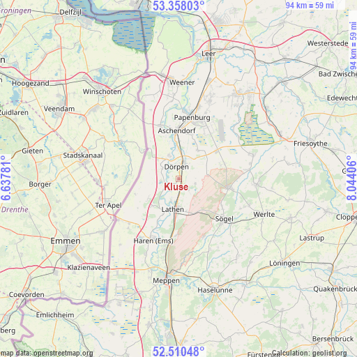
Kluse GPS coordinates[2]
52° 56' 10.788" North, 7° 20' 27.348" East
| Map corner | latitude | longitude |
|---|---|---|
| Upper-left | 53.35803°, | 6.63781° |
| Center: | 52.93633°, | 7.34093° |
| Lower-right: | 52.51048°, | 8.04406° |
| Map W x H: | 94.2×94.2 km | = 58.5×58.5mi |
| max Lat: | 55.01917° ⇑18.7% North |
| Kluse: | 52.93633° |
| min Lat: | ⇓81.3% South 47.40724° |
| min Long | Kluse | max Long |
| 5.92978° | 7.34093° | 14.98853° |
| W 10.7%⇐ | ⇒89.3% E |
Elevation
Elevation of Kluse is 7 m = 23 ft, and this is 242.1 m = 794 ft below average elevation for this country.
| Max E: |
1256 m = 4121 ft | 95.6% |
| Avg. | 249.1 m = 817 ft | |
| Kluse | 7 m = 23 ft | |
Min E: |
-5 m = -16 ft | 4.4% |
See also: Germany elevation on elevation.city.
Geographical zone
Kluse is located in North temperate zone (between Tropic of Cancer and the Arctic Circle). Distance of this North polar circle is 1515.2 km =941.5 mi to North.| Distance of | km | miles | from Kluse |
|---|---|---|---|
| North Pole | 4121.1 | 2560.7 | to North |
| Arctic Circle | 1515.2 | 941.5 | to North |
| Tropic Cancer | 3280 | 2038.1 | to South |
| Equator | 5886 | 3657.4 | to South |


Nearby cities:
15 places around Kluse: (largest is in red/bold)
• Dersum
5.3 km =3.3 mi,  301°
301°
• Dörpen
3.4 km =2.1 mi,  338°
338°
• Fresenburg
6.5 km =4 mi,  204°
204°
• Heede
6.8 km =4.2 mi, 335°
• Lathen
7.9 km =4.9 mi,  191°
191°
• Lehe
7.1 km =4.4 mi,  355°
355°
• Neubörger
7.6 km =4.7 mi,  71°
71°
• Neulehe
9 km =5.6 mi,  32°
32°
• Niederlangen
9.7 km =6 mi, 204°
• Oberlangen
10.8 km =6.7 mi,  207°
207°
• Renkenberge
4.9 km =3 mi,  144°
144°
• Surwold
12.6 km =7.8 mi, 68°
• Sustrum
4.4 km =2.7 mi,  240°
240°
• Walchum
4 km =2.5 mi,  255°
255°
• Wippingen
4.7 km =2.9 mi,  107°
107°
Sources, notices
• [Note1] Compared only with cities in Germany existing in our database
• [Src1] Map data: © OpenStreetMap contributors (CC-BY-SA)
• [Src2] Other city data from geonames.org with taken over terms of usage.
• [Src3] Geographical zone / Annual Mean Temperature by Robert A. Rohde @ Wikipedia
