Neulehe geodata
Neulehe (Lower Saxony) is a seat of a fourth-order administrative division; located in Germany in Europe/Berlin (GMT+2) time zone. With population of 717 people, there are 8240 cities with bigger population in this country. Compared to other cities in Germany, 81.7% of cities are located further ↓South; 88.4% of cities are located further →East and 94.8% of cities have higher elevation than Neulehe. Note1


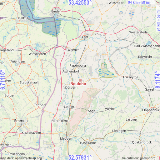
Neulehe GPS coordinates[2]
53° 0' 16.164" North, 7° 24' 51.408" East
| Map corner | latitude | longitude |
|---|---|---|
| Upper-left | 53.42553°, | 6.71115° |
| Center: | 53.00449°, | 7.41428° |
| Lower-right: | 52.57931°, | 8.1174° |
| Map W x H: | 94.1×94.1 km | = 58.5×58.5mi |
| max Lat: | 55.01917° ⇑18.3% North |
| Neulehe: | 53.00449° |
| min Lat: | ⇓81.7% South 47.40724° |
| min Long | Neulehe | max Long |
| 5.92978° | 7.41428° | 14.98853° |
| W 11.6%⇐ | ⇒88.4% E |
Elevation
Elevation of Neulehe is 9 m = 30 ft, and this is 240.1 m = 788 ft below average elevation for this country.
| Max E: |
1256 m = 4121 ft | 94.8% |
| Avg. | 249.1 m = 817 ft | |
| Neulehe | 9 m = 30 ft | |
Min E: |
-5 m = -16 ft | 5.2% |
See also: Germany elevation on elevation.city.
Geographical zone
Neulehe is located in North temperate zone (between Tropic of Cancer and the Arctic Circle). Distance of this North polar circle is 1507.6 km =936.8 mi to North.| Distance of | km | miles | from Neulehe |
|---|---|---|---|
| North Pole | 4113.5 | 2556 | to North |
| Arctic Circle | 1507.6 | 936.8 | to North |
| Tropic Cancer | 3287.6 | 2042.8 | to South |
| Equator | 5893.5 | 3662 | to South |


Nearby cities:
15 places around Neulehe: (largest is in red/bold)
• Bockhorst
11.3 km =7 mi,  73°
73°
• Börger
13.1 km =8.1 mi,  141°
141°
• Dersum
10.6 km =6.6 mi,  242°
242°
• Dörpen
7.6 km =4.7 mi,  234°
234°
• Heede
7.9 km =4.9 mi,  259°
259°
• Kluse
9 km =5.6 mi,  212°
212°
• Lehe
5.4 km =3.4 mi, 264°
• Nenndorf
11.1 km =6.9 mi,  329°
329°
• Neubörger
5.6 km =3.5 mi,  156°
156°
• Papenburg
8.1 km =5 mi,  355°
355°
• Renkenberge
11.8 km =7.3 mi,  190°
190°
• Rhede
11.4 km =7.1 mi,  302°
302°
• Surwold
7.4 km =4.6 mi,  113°
113°
• Walchum
12.3 km =7.6 mi, 225°
• Wippingen
9 km =5.6 mi,  182°
182°
Sources, notices
• [Note1] Compared only with cities in Germany existing in our database
• [Src1] Map data: © OpenStreetMap contributors (CC-BY-SA)
• [Src2] Other city data from geonames.org with taken over terms of usage.
• [Src3] Geographical zone / Annual Mean Temperature by Robert A. Rohde @ Wikipedia
