Sterup geodata
Sterup (Schleswig-Holstein) is a seat of a fourth-order administrative division; located in Germany in Europe/Berlin (GMT+2) time zone. With population of 1,449 people, there are 5978 cities with bigger population in this country. Compared to other cities in Germany, 99.3% of cities are located further ↓South; 53.7% of cities are located further →East and 83.2% of cities have higher elevation than Sterup. Note1
Administrative division(s):
- Level 1: Schleswig-Holstein
- Level 3: Kreis Schleswig-Flensburg
- Level 4: Sterup


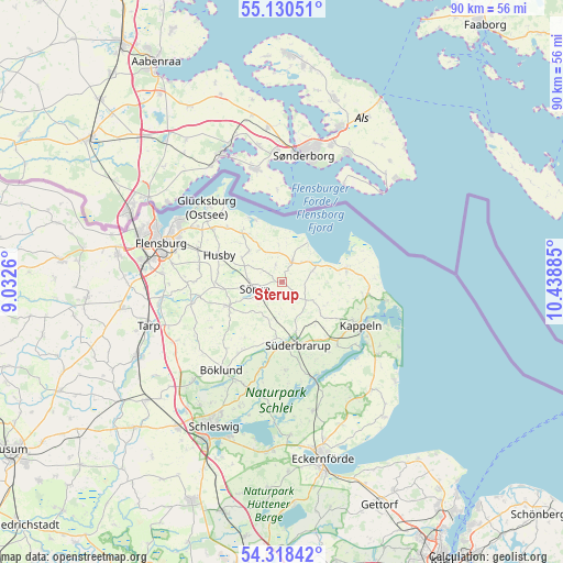
Sterup GPS coordinates[2]
54° 43' 35.4" North, 9° 44' 8.592" East
| Map corner | latitude | longitude |
|---|---|---|
| Upper-left | 55.13051°, | 9.0326° |
| Center: | 54.7265°, | 9.73572° |
| Lower-right: | 54.31842°, | 10.43885° |
| Map W x H: | 90.3×90.3 km | = 56.1×56.1mi |
| max Lat: | 55.01917° ⇑0.7% North |
| Sterup: | 54.7265° |
| min Lat: | ⇓99.3% South 47.40724° |
| min Long | Sterup | max Long |
| 5.92978° | 9.73572° | 14.98853° |
| W 46.3%⇐ | ⇒53.7% E |
Elevation
Elevation of Sterup is 39 m = 128 ft, and this is 210.1 m = 689 ft below average elevation for this country.
| Max E: |
1256 m = 4121 ft | 83.2% |
| Avg. | 249.1 m = 817 ft | |
| Sterup | 39 m = 128 ft | |
Min E: |
-5 m = -16 ft | 16.8% |
See also: Germany elevation on elevation.city.
Geographical zone
Sterup is located in North temperate zone (between Tropic of Cancer and the Arctic Circle). Distance of this North polar circle is 1316.2 km =817.8 mi to North.| Distance of | km | miles | from Sterup |
|---|---|---|---|
| North Pole | 3922 | 2437 | to North |
| Arctic Circle | 1316.2 | 817.8 | to North |
| Tropic Cancer | 3479.1 | 2161.8 | to South |
| Equator | 6085 | 3781 | to South |


Nearby cities:
15 places around Sterup: (largest is in red/bold)
• Ahneby
1.1 km =0.7 mi,  187°
187°
• Dollerup
6.8 km =4.2 mi,  327°
327°
• Esgrus
3.2 km =2 mi,  109°
109°
• Grundhof
7.2 km =4.5 mi,  312°
312°
• Mohrkirch
6.8 km =4.2 mi, 190°
• Niesgrau
5.8 km =3.6 mi,  63°
63°
• Norderbrarup
8.3 km =5.2 mi,  165°
165°
• Quern
2.9 km =1.8 mi, 334°
• Rügge
5.2 km =3.2 mi,  157°
157°
• Saustrup
6.9 km =4.3 mi, 163°
• Scheggerott
8.4 km =5.2 mi,  141°
141°
• Steinberg
5.4 km =3.4 mi,  34°
34°
• Steinbergkirche
3.5 km =2.2 mi, 27°
• Sörup
4.6 km =2.9 mi,  256°
256°
• Wagersrott
7.8 km =4.8 mi,  148°
148°
Sources, notices
• [Note1] Compared only with cities in Germany existing in our database
• [Src1] Map data: © OpenStreetMap contributors (CC-BY-SA)
• [Src2] Other city data from geonames.org with taken over terms of usage.
• [Src3] Geographical zone / Annual Mean Temperature by Robert A. Rohde @ Wikipedia
