Scheggerott geodata
Scheggerott (Schleswig-Holstein) is a seat of a fourth-order administrative division; located in Germany in Europe/Berlin (GMT+2) time zone. With population of 388 people, there are 9729 cities with bigger population in this country. Compared to other cities in Germany, 99% of cities are located further ↓South; 52.6% of cities are located further →East and 88.3% of cities have higher elevation than Scheggerott. Note1
Administrative division(s):
- Level 1: Schleswig-Holstein
- Level 3: Kreis Schleswig-Flensburg
- Level 4: Scheggerott


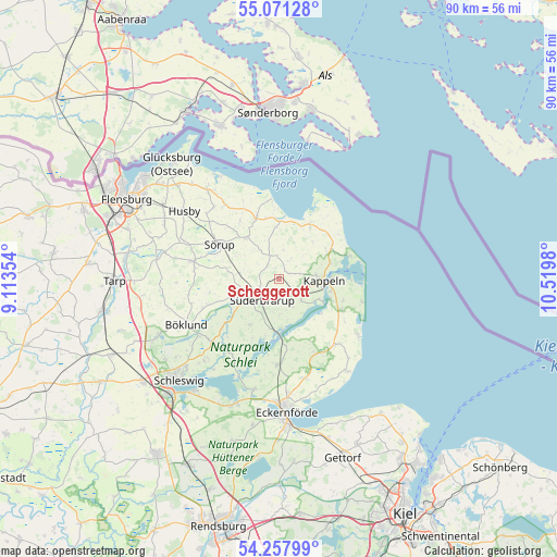
Scheggerott GPS coordinates[2]
54° 40' 0.012" North, 9° 49' 0.012" East
| Map corner | latitude | longitude |
|---|---|---|
| Upper-left | 55.07128°, | 9.11354° |
| Center: | 54.66667°, | 9.81667° |
| Lower-right: | 54.25799°, | 10.5198° |
| Map W x H: | 90.4×90.4 km | = 56.2×56.2mi |
| max Lat: | 55.01917° ⇑1% North |
| Scheggerott: | 54.66667° |
| min Lat: | ⇓99% South 47.40724° |
| min Long | Scheggerott | max Long |
| 5.92978° | 9.81667° | 14.98853° |
| W 47.4%⇐ | ⇒52.6% E |
Elevation
Elevation of Scheggerott is 26 m = 85 ft, and this is 223.1 m = 732 ft below average elevation for this country.
| Max E: |
1256 m = 4121 ft | 88.3% |
| Avg. | 249.1 m = 817 ft | |
| Scheggerott | 26 m = 85 ft | |
Min E: |
-5 m = -16 ft | 11.7% |
See also: Germany elevation on elevation.city.
Geographical zone
Scheggerott is located in North temperate zone (between Tropic of Cancer and the Arctic Circle). Distance of this North polar circle is 1322.8 km =821.9 mi to North.| Distance of | km | miles | from Scheggerott |
|---|---|---|---|
| North Pole | 3928.7 | 2441.2 | to North |
| Arctic Circle | 1322.8 | 821.9 | to North |
| Tropic Cancer | 3472.4 | 2157.6 | to South |
| Equator | 6078.4 | 3776.9 | to South |


Nearby cities:
15 places around Scheggerott: (largest is in red/bold)
• Boren
5.7 km =3.5 mi,  177°
177°
• Brebel
5.7 km =3.5 mi,  229°
229°
• Dollrottfeld
3.7 km =2.3 mi, 180°
• Esgrus
6 km =3.7 mi,  338°
338°
• Mohrkirch
6.4 km =4 mi,  270°
270°
• Norderbrarup
3.4 km =2.1 mi,  245°
245°
• Nottfeld
6.4 km =4 mi,  210°
210°
• Oersberg
2.1 km =1.3 mi,  90°
90°
• Rabenkirchen-Faulück
4.3 km =2.7 mi,  149°
149°
• Rügge
3.7 km =2.3 mi,  299°
299°
• Saustrup
3.2 km =2 mi, 270°
• Stangheck
6.4 km =4 mi,  30°
30°
• Stoltebüll
5.7 km =3.5 mi,  49°
49°
• Süderbrarup
4.3 km =2.7 mi, 210°
• Wagersrott
1.1 km =0.7 mi, 270°
Sources, notices
• [Note1] Compared only with cities in Germany existing in our database
• [Src1] Map data: © OpenStreetMap contributors (CC-BY-SA)
• [Src2] Other city data from geonames.org with taken over terms of usage.
• [Src3] Geographical zone / Annual Mean Temperature by Robert A. Rohde @ Wikipedia
