Sörup geodata
Sörup (Schleswig-Holstein) is a seat of a fourth-order administrative division; located in Germany in Europe/Berlin (GMT+2) time zone. With population of 4,118 people, there are 3216 cities with bigger population in this country. Compared to other cities in Germany, 99.3% of cities are located further ↓South; 55% of cities are located further →East and 83.2% of cities have higher elevation than Sörup. Note1
Administrative division(s):
- Level 1: Schleswig-Holstein
- Level 3: Kreis Schleswig-Flensburg
- Level 4: Sörup


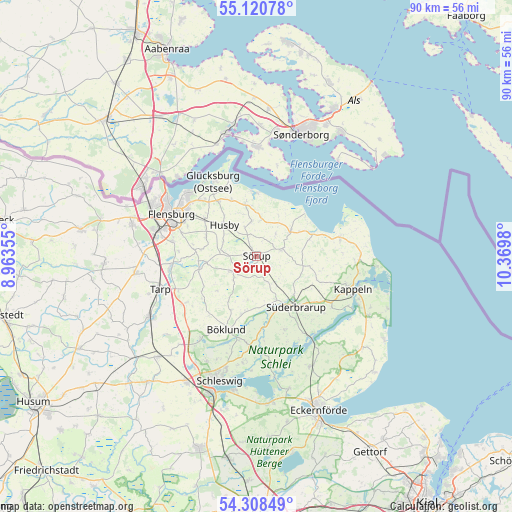
Sörup GPS coordinates[2]
54° 43' 0.012" North, 9° 40' 0.012" East
| Map corner | latitude | longitude |
|---|---|---|
| Upper-left | 55.12078°, | 8.96355° |
| Center: | 54.71667°, | 9.66667° |
| Lower-right: | 54.30849°, | 10.3698° |
| Map W x H: | 90.3×90.3 km | = 56.1×56.1mi |
| max Lat: | 55.01917° ⇑0.7% North |
| Sörup: | 54.71667° |
| min Lat: | ⇓99.3% South 47.40724° |
| min Long | Sörup | max Long |
| 5.92978° | 9.66667° | 14.98853° |
| W 45%⇐ | ⇒55% E |
Elevation
Elevation of Sörup is 39 m = 128 ft, and this is 210.1 m = 689 ft below average elevation for this country.
| Max E: |
1256 m = 4121 ft | 83.2% |
| Avg. | 249.1 m = 817 ft | |
| Sörup | 39 m = 128 ft | |
Min E: |
-5 m = -16 ft | 16.8% |
See also: Germany elevation on elevation.city.
Geographical zone
Sörup is located in North temperate zone (between Tropic of Cancer and the Arctic Circle). Distance of this North polar circle is 1317.3 km =818.5 mi to North.| Distance of | km | miles | from Sörup |
|---|---|---|---|
| North Pole | 3923.1 | 2437.7 | to North |
| Arctic Circle | 1317.3 | 818.5 | to North |
| Tropic Cancer | 3478 | 2161.1 | to South |
| Equator | 6083.9 | 3780.4 | to South |


Nearby cities:
15 places around Sörup: (largest is in red/bold)
• Ahneby
4.3 km =2.7 mi,  90°
90°
• Ausacker
6.7 km =4.2 mi,  286°
286°
• Böel
8.1 km =5 mi,  156°
156°
• Dollerup
6.9 km =4.3 mi,  7°
7°
• Esgrus
7.5 km =4.7 mi, 90°
• Grundhof
6.1 km =3.8 mi,  351°
351°
• Husby
7.7 km =4.8 mi,  316°
316°
• Mohrkirch
6.4 km =4 mi,  149°
149°
• Quern
4.9 km =3 mi,  40°
40°
• Rügge
7.4 km =4.6 mi,  119°
119°
• Satrup
4.8 km =3 mi,  235°
235°
• Saustrup
8.5 km =5.3 mi,  130°
130°
• Schnarup-Thumby
7.5 km =4.7 mi,  188°
188°
• Steinbergkirche
7.4 km =4.6 mi,  55°
55°
• Sterup
4.6 km =2.9 mi,  76°
76°
Sources, notices
• [Note1] Compared only with cities in Germany existing in our database
• [Src1] Map data: © OpenStreetMap contributors (CC-BY-SA)
• [Src2] Other city data from geonames.org with taken over terms of usage.
• [Src3] Geographical zone / Annual Mean Temperature by Robert A. Rohde @ Wikipedia
