Steindorf geodata
Steindorf (Bavaria) is a seat of a fourth-order administrative division; located in Germany in Europe/Berlin (GMT+2) time zone. With population of 943 people, there are 7371 cities with bigger population in this country. Compared to other cities in Germany, 92.5% of cities are located further ↑North; 66.9% of cities are located further ←West and 92% of cities have lower elevation than Steindorf. Note1
Administrative division(s):
- Level 1: Bavaria
- Level 2: Swabia
- Level 3: Landkreis Aichach-Friedberg
- Level 4: Steindorf


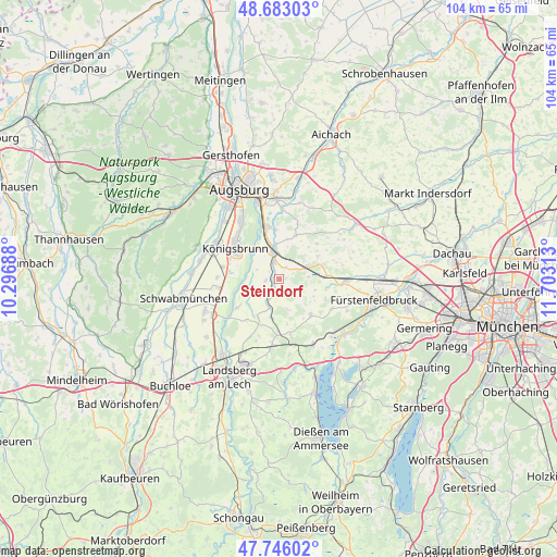
Steindorf GPS coordinates[2]
48° 13' 0.012" North, 11° 0' 0" East
| Map corner | latitude | longitude |
|---|---|---|
| Upper-left | 48.68303°, | 10.29688° |
| Center: | 48.21667°, | 11° |
| Lower-right: | 47.74602°, | 11.70313° |
| Map W x H: | 104.2×104.2 km | = 64.7×64.7mi |
| max Lat: | 55.01917° ⇑92.5% North |
| Steindorf: | 48.21667° |
| min Lat: | ⇓7.5% South 47.40724° |
| min Long | Steindorf | max Long |
| 5.92978° | 11° | 14.98853° |
| W 66.9%⇐ | ⇒33.1% E |
Elevation
Elevation of Steindorf is 542 m = 1778 ft, and this is 292.9 m = 961 ft above average elevation for this country.
| Max E: |
1256 m = 4121 ft | 8% |
| Steindorf | 542 m 1778 ft | |
| Avg. | 249.1 m = 817 ft | |
Min E: |
-5 m = -16 ft | 92% |
See also: Germany elevation on elevation.city.
Geographical zone
Steindorf is located in North temperate zone (between Tropic of Cancer and the Arctic Circle). Distance of this North polar circle is 2040 km =1267.6 mi to North.| Distance of | km | miles | from Steindorf |
|---|---|---|---|
| North Pole | 4645.9 | 2886.8 | to North |
| Arctic Circle | 2040 | 1267.6 | to North |
| Tropic Cancer | 2755.3 | 1712.1 | to South |
| Equator | 5361.2 | 3331.3 | to South |


Nearby cities:
15 places around Steindorf: (largest is in red/bold)
• Adelshofen
9.4 km =5.8 mi,  113°
113°
• Althegnenberg
5.3 km =3.3 mi,  69°
69°
• Brunnen
2.4 km =1.5 mi,  305°
305°
• Egling
3.8 km =2.4 mi,  207°
207°
• Hattenhofen
8.6 km =5.3 mi,  85°
85°
• Kissing
9.9 km =6.2 mi,  347°
347°
• Kleinaitingen
9.7 km =6 mi,  271°
271°
• Merching
3.4 km =2.1 mi,  341°
341°
• Mering
5.6 km =3.5 mi, 348°
• Mittelstetten
8.3 km =5.2 mi,  63°
63°
• Moorenweis
8.9 km =5.5 mi,  139°
139°
• Prittriching
5.6 km =3.5 mi,  251°
251°
• Ried
8.8 km =5.5 mi,  21°
21°
• Scheuring
9.5 km =5.9 mi,  234°
234°
• Schmiechen
2.5 km =1.6 mi, 270°
Sources, notices
• [Note1] Compared only with cities in Germany existing in our database
• [Src1] Map data: © OpenStreetMap contributors (CC-BY-SA)
• [Src2] Other city data from geonames.org with taken over terms of usage.
• [Src3] Geographical zone / Annual Mean Temperature by Robert A. Rohde @ Wikipedia
