Brunnen geodata
Brunnen (Bavaria) is a populated place; located in Germany in Europe/Berlin (GMT+2) time zone. With population of 1,609 people, there are 5668 cities with bigger population in this country. Compared to other cities in Germany, 92.3% of cities are located further ↑North; 66.6% of cities are located further ←West and 91.1% of cities have lower elevation than Brunnen. Note1
Administrative division(s):
- Level 1: Bavaria
- Level 2: Swabia
- Level 3: Landkreis Aichach-Friedberg
- Level 4: Merching


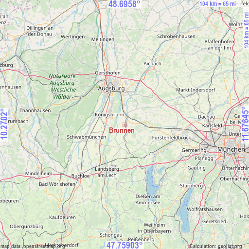
Brunnen GPS coordinates[2]
48° 13' 46.416" North, 10° 58' 23.952" East
| Map corner | latitude | longitude |
|---|---|---|
| Upper-left | 48.6958°, | 10.2702° |
| Center: | 48.22956°, | 10.97332° |
| Lower-right: | 47.75903°, | 11.67645° |
| Map W x H: | 104.2×104.2 km | = 64.7×64.7mi |
| max Lat: | 55.01917° ⇑92.3% North |
| Brunnen: | 48.22956° |
| min Lat: | ⇓7.7% South 47.40724° |
| min Long | Brunnen | max Long |
| 5.92978° | 10.97332° | 14.98853° |
| W 66.6%⇐ | ⇒33.4% E |
Elevation
Elevation of Brunnen is 528 m = 1732 ft, and this is 278.9 m = 915 ft above average elevation for this country.
| Max E: |
1256 m = 4121 ft | 8.9% |
| Brunnen | 528 m 1732 ft | |
| Avg. | 249.1 m = 817 ft | |
Min E: |
-5 m = -16 ft | 91.1% |
See also: Germany elevation on elevation.city.
Geographical zone
Brunnen is located in North temperate zone (between Tropic of Cancer and the Arctic Circle). Distance of this North polar circle is 2038.5 km =1266.7 mi to North.| Distance of | km | miles | from Brunnen |
|---|---|---|---|
| North Pole | 4644.4 | 2885.9 | to North |
| Arctic Circle | 2038.5 | 1266.7 | to North |
| Tropic Cancer | 2756.7 | 1712.9 | to South |
| Equator | 5362.6 | 3332.2 | to South |


Nearby cities:
15 places around Brunnen: (largest is in red/bold)
• Althegnenberg
6.9 km =4.3 mi,  86°
86°
• Egling
4.8 km =3 mi,  177°
177°
• Hattenhofen
10.6 km =6.6 mi, 94°
• Kissing
8.3 km =5.2 mi,  358°
358°
• Kleinaitingen
7.8 km =4.8 mi,  260°
260°
• Königsbrunn
7.9 km =4.9 mi,  309°
309°
• Merching
2 km =1.2 mi,  25°
25°
• Mering
4.1 km =2.5 mi,  11°
11°
• Mittelstetten
9.7 km =6 mi,  76°
76°
• Oberottmarshausen
8.6 km =5.3 mi,  275°
275°
• Prittriching
4.6 km =2.9 mi,  226°
226°
• Ried
8.5 km =5.3 mi,  37°
37°
• Scheuring
9 km =5.6 mi,  219°
219°
• Schmiechen
1.5 km =0.9 mi,  198°
198°
• Steindorf
2.4 km =1.5 mi,  125°
125°
Sources, notices
• [Note1] Compared only with cities in Germany existing in our database
• [Src1] Map data: © OpenStreetMap contributors (CC-BY-SA)
• [Src2] Other city data from geonames.org with taken over terms of usage.
• [Src3] Geographical zone / Annual Mean Temperature by Robert A. Rohde @ Wikipedia
