Stahlberg geodata
Stahlberg (Rheinland-Pfalz) is a seat of a fourth-order administrative division; located in Germany in Europe/Berlin (GMT+2) time zone. With population of 198 people, there are 10479 cities with bigger population in this country. Compared to other cities in Germany, 72.2% of cities are located further ↑North; 81.3% of cities are located further →East and 73.7% of cities have lower elevation than Stahlberg. Note1


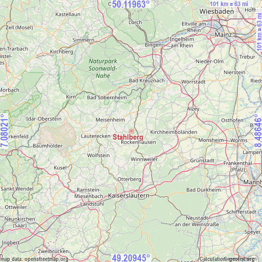
Stahlberg GPS coordinates[2]
49° 40' 0.012" North, 7° 46' 59.988" East
| Map corner | latitude | longitude |
|---|---|---|
| Upper-left | 50.11963°, | 7.08021° |
| Center: | 49.66667°, | 7.78333° |
| Lower-right: | 49.20945°, | 8.48646° |
| Map W x H: | 101.2×101.2 km | = 62.9×62.9mi |
| max Lat: | 55.01917° ⇑72.2% North |
| Stahlberg: | 49.66667° |
| min Lat: | ⇓27.8% South 47.40724° |
| min Long | Stahlberg | max Long |
| 5.92978° | 7.78333° | 14.98853° |
| W 18.7%⇐ | ⇒81.3% E |
Elevation
Elevation of Stahlberg is 388 m = 1273 ft, and this is 138.9 m = 456 ft above average elevation for this country.
| Max E: |
1256 m = 4121 ft | 26.3% |
| Stahlberg | 388 m 1273 ft | |
| Avg. | 249.1 m = 817 ft | |
Min E: |
-5 m = -16 ft | 73.7% |
See also: Germany elevation on elevation.city.
Geographical zone
Stahlberg is located in North temperate zone (between Tropic of Cancer and the Arctic Circle). Distance of this North polar circle is 1878.8 km =1167.4 mi to North.| Distance of | km | miles | from Stahlberg |
|---|---|---|---|
| North Pole | 4484.6 | 2786.6 | to North |
| Arctic Circle | 1878.8 | 1167.4 | to North |
| Tropic Cancer | 2916.5 | 1812.2 | to South |
| Equator | 5522.4 | 3431.5 | to South |


Nearby cities:
15 places around Stahlberg: (largest is in red/bold)
• Bayerfeld-Steckweiler
2.2 km =1.4 mi,  32°
32°
• Bisterschied
3 km =1.9 mi,  232°
232°
• Dielkirchen
2.4 km =1.5 mi,  90°
90°
• Finkenbach-Gersweiler
3 km =1.9 mi,  307°
307°
• Gerbach
6 km =3.7 mi, 90°
• Katzenbach
3 km =1.9 mi,  142°
142°
• Mannweiler-Cölln
1.9 km =1.2 mi,  0°
0°
• Oberndorf
6.1 km =3.8 mi,  23°
23°
• Ransweiler
1.2 km =0.7 mi,  270°
270°
• Rockenhausen
4.9 km =3 mi,  146°
146°
• Schiersfeld
3.9 km =2.4 mi,  342°
342°
• Schönborn
3.9 km =2.4 mi,  197°
197°
• Sitters
5.6 km =3.5 mi, 0°
• Teschenmoschel
5.2 km =3.2 mi,  224°
224°
• Waldgrehweiler
3.6 km =2.2 mi, 270°
Sources, notices
• [Note1] Compared only with cities in Germany existing in our database
• [Src1] Map data: © OpenStreetMap contributors (CC-BY-SA)
• [Src2] Other city data from geonames.org with taken over terms of usage.
• [Src3] Geographical zone / Annual Mean Temperature by Robert A. Rohde @ Wikipedia
