Sommersdorf geodata
Sommersdorf (Saxony-Anhalt) is a seat of a fourth-order administrative division; located in Germany in Europe/Berlin (GMT+2) time zone. With population of 1,108 people, there are 6826 cities with bigger population in this country. Compared to other cities in Germany, 73.7% of cities are located further ↓South; 68.1% of cities are located further ←West and 62.9% of cities have higher elevation than Sommersdorf. Note1


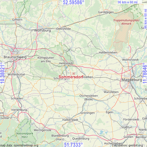
Sommersdorf GPS coordinates[2]
52° 10' 0.012" North, 11° 4' 59.988" East
| Map corner | latitude | longitude |
|---|---|---|
| Upper-left | 52.59586°, | 10.38021° |
| Center: | 52.16667°, | 11.08333° |
| Lower-right: | 51.7333°, | 11.78646° |
| Map W x H: | 95.9×95.9 km | = 59.6×59.6mi |
| max Lat: | 55.01917° ⇑26.3% North |
| Sommersdorf: | 52.16667° |
| min Lat: | ⇓73.7% South 47.40724° |
| min Long | Sommersdorf | max Long |
| 5.92978° | 11.08333° | 14.98853° |
| W 68.1%⇐ | ⇒31.9% E |
Elevation
Elevation of Sommersdorf is 133 m = 436 ft, and this is 116.1 m = 381 ft below average elevation for this country.
| Max E: |
1256 m = 4121 ft | 62.9% |
| Avg. | 249.1 m = 817 ft | |
| Sommersdorf | 133 m = 436 ft | |
Min E: |
-5 m = -16 ft | 37.1% |
See also: Germany elevation on elevation.city.
Geographical zone
Sommersdorf is located in North temperate zone (between Tropic of Cancer and the Arctic Circle). Distance of this North polar circle is 1600.8 km =994.7 mi to North.| Distance of | km | miles | from Sommersdorf |
|---|---|---|---|
| North Pole | 4206.7 | 2613.9 | to North |
| Arctic Circle | 1600.8 | 994.7 | to North |
| Tropic Cancer | 3194.5 | 1985 | to South |
| Equator | 5800.4 | 3604.2 | to South |


Nearby cities:
15 places around Sommersdorf: (largest is in red/bold)
• Ausleben
8.7 km =5.4 mi,  167°
167°
• Barneberg
5.1 km =3.2 mi,  185°
185°
• Beendorf
8.5 km =5.3 mi,  1°
1°
• Büddenstedt
4.4 km =2.7 mi,  275°
275°
• Eilsleben
8.9 km =5.5 mi,  104°
104°
• Eimersleben
10.1 km =6.3 mi,  52°
52°
• Harbke
3.5 km =2.2 mi,  314°
314°
• Helmstedt
8.5 km =5.3 mi,  323°
323°
• Hötensleben
6.7 km =4.2 mi,  218°
218°
• Marienborn
3.6 km =2.2 mi,  26°
26°
• Schöningen
8.5 km =5.3 mi,  248°
248°
• Ummendorf
6.8 km =4.2 mi, 99°
• Völpke
3.3 km =2.1 mi,  161°
161°
• Wefensleben
5.6 km =3.5 mi,  70°
70°
• Wormsdorf
8.4 km =5.2 mi,  116°
116°
Sources, notices
• [Note1] Compared only with cities in Germany existing in our database
• [Src1] Map data: © OpenStreetMap contributors (CC-BY-SA)
• [Src2] Other city data from geonames.org with taken over terms of usage.
• [Src3] Geographical zone / Annual Mean Temperature by Robert A. Rohde @ Wikipedia
