Schöningen geodata
Schöningen (Lower Saxony) is a populated place; located in Germany in Europe/Berlin (GMT+2) time zone. With population of 13,265 people, there are 1208 cities with bigger population in this country. Compared to other cities in Germany, 73.4% of cities are located further ↓South; 66.5% of cities are located further ←West and 62.3% of cities have higher elevation than Schöningen. Note1


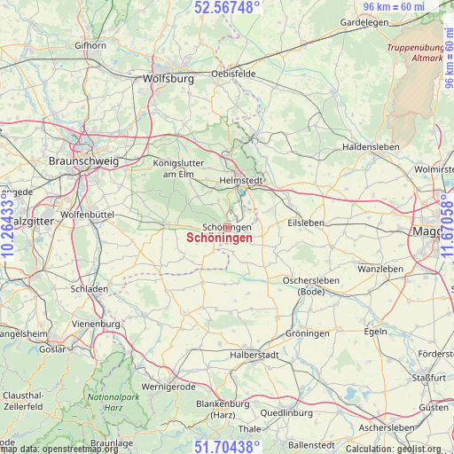
Schöningen GPS coordinates[2]
52° 8' 16.872" North, 10° 58' 2.82" East
| Map corner | latitude | longitude |
|---|---|---|
| Upper-left | 52.56748°, | 10.26433° |
| Center: | 52.13802°, | 10.96745° |
| Lower-right: | 51.70438°, | 11.67058° |
| Map W x H: | 96×96 km | = 59.7×59.7mi |
| max Lat: | 55.01917° ⇑26.6% North |
| Schöningen: | 52.13802° |
| min Lat: | ⇓73.4% South 47.40724° |
| min Long | Schöningen | max Long |
| 5.92978° | 10.96745° | 14.98853° |
| W 66.5%⇐ | ⇒33.5% E |
Elevation
Elevation of Schöningen is 136 m = 446 ft, and this is 113.1 m = 371 ft below average elevation for this country.
| Max E: |
1256 m = 4121 ft | 62.3% |
| Avg. | 249.1 m = 817 ft | |
| Schöningen | 136 m = 446 ft | |
Min E: |
-5 m = -16 ft | 37.7% |
See also: Germany elevation on elevation.city.
Geographical zone
Schöningen is located in North temperate zone (between Tropic of Cancer and the Arctic Circle). Distance of this North polar circle is 1604 km =996.7 mi to North.| Distance of | km | miles | from Schöningen |
|---|---|---|---|
| North Pole | 4209.9 | 2615.9 | to North |
| Arctic Circle | 1604 | 996.7 | to North |
| Tropic Cancer | 3191.3 | 1983 | to South |
| Equator | 5797.2 | 3602.2 | to South |


Nearby cities:
15 places around Schöningen: (largest is in red/bold)
• Barneberg
7.6 km =4.7 mi,  103°
103°
• Büddenstedt
5 km =3.1 mi,  44°
44°
• Dahlum
8 km =5 mi,  266°
266°
• Frellstedt
8.3 km =5.2 mi,  334°
334°
• Harbke
7.8 km =4.8 mi, 43°
• Hötensleben
4.3 km =2.7 mi,  118°
118°
• Ingeleben
7.3 km =4.5 mi,  241°
241°
• Jerxheim
7.8 km =4.8 mi,  216°
216°
• Räbke
8.8 km =5.5 mi,  316°
316°
• Sommersdorf
8.5 km =5.3 mi,  68°
68°
• Söllingen
6.1 km =3.8 mi,  208°
208°
• Twieflingen
3.8 km =2.4 mi,  247°
247°
• Wackersleben
8.3 km =5.2 mi,  155°
155°
• Warberg
5.8 km =3.6 mi, 325°
• Wolsdorf
6.2 km =3.9 mi,  341°
341°
Sources, notices
• [Note1] Compared only with cities in Germany existing in our database
• [Src1] Map data: © OpenStreetMap contributors (CC-BY-SA)
• [Src2] Other city data from geonames.org with taken over terms of usage.
• [Src3] Geographical zone / Annual Mean Temperature by Robert A. Rohde @ Wikipedia
