Sienhachenbach geodata
Sienhachenbach (Rheinland-Pfalz) is a seat of a fourth-order administrative division; located in Germany in Europe/Berlin (GMT+2) time zone. With population of 230 people, there are 10349 cities with bigger population in this country. Compared to other cities in Germany, 71.5% of cities are located further ↑North; 87.4% of cities are located further →East and 66.7% of cities have lower elevation than Sienhachenbach. Note1
Administrative division(s):
- Level 1: Rheinland-Pfalz
- Level 3: Landkreis Birkenfeld
- Level 4: Sienhachenbach


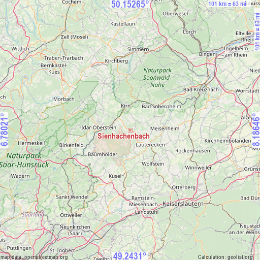
Sienhachenbach GPS coordinates[2]
49° 42' 0" North, 7° 28' 59.988" East
| Map corner | latitude | longitude |
|---|---|---|
| Upper-left | 50.15265°, | 6.78021° |
| Center: | 49.7°, | 7.48333° |
| Lower-right: | 49.2431°, | 8.18646° |
| Map W x H: | 101.1×101.1 km | = 62.8×62.8mi |
| max Lat: | 55.01917° ⇑71.5% North |
| Sienhachenbach: | 49.7° |
| min Lat: | ⇓28.5% South 47.40724° |
| min Long | Sienhachenbach | max Long |
| 5.92978° | 7.48333° | 14.98853° |
| W 12.6%⇐ | ⇒87.4% E |
Elevation
Elevation of Sienhachenbach is 333 m = 1093 ft, and this is 83.9 m = 275 ft above average elevation for this country.
| Max E: |
1256 m = 4121 ft | 33.3% |
| Sienhachenbach | 333 m 1093 ft | |
| Avg. | 249.1 m = 817 ft | |
Min E: |
-5 m = -16 ft | 66.7% |
See also: Germany elevation on elevation.city.
Geographical zone
Sienhachenbach is located in North temperate zone (between Tropic of Cancer and the Arctic Circle). Distance of this North polar circle is 1875.1 km =1165.1 mi to North.| Distance of | km | miles | from Sienhachenbach |
|---|---|---|---|
| North Pole | 4480.9 | 2784.3 | to North |
| Arctic Circle | 1875.1 | 1165.1 | to North |
| Tropic Cancer | 2920.2 | 1814.5 | to South |
| Equator | 5526.1 | 3433.8 | to South |


Nearby cities:
15 places around Sienhachenbach: (largest is in red/bold)
• Bärenbach
6.1 km =3.8 mi,  336°
336°
• Dickesbach
5.1 km =3.2 mi,  291°
291°
• Homberg
6.1 km =3.8 mi,  156°
156°
• Hoppstädten
3.6 km =2.2 mi,  90°
90°
• Hundsbach
5.1 km =3.2 mi,  68°
68°
• Langweiler
4.4 km =2.7 mi,  147°
147°
• Limbach
6.1 km =3.8 mi,  52°
52°
• Merzweiler
5.2 km =3.2 mi,  135°
135°
• Mittelreidenbach
4.2 km =2.6 mi,  314°
314°
• Oberreidenbach
1.8 km =1.1 mi,  295°
295°
• Otzweiler
3 km =1.9 mi, 52°
• Schmidthachenbach
3.9 km =2.4 mi, 342°
• Schweinschied
6 km =3.7 mi, 90°
• Sien
1.6 km =1 mi,  111°
111°
• Unterjeckenbach
3.7 km =2.3 mi,  180°
180°
Sources, notices
• [Note1] Compared only with cities in Germany existing in our database
• [Src1] Map data: © OpenStreetMap contributors (CC-BY-SA)
• [Src2] Other city data from geonames.org with taken over terms of usage.
• [Src3] Geographical zone / Annual Mean Temperature by Robert A. Rohde @ Wikipedia
