Mittelreidenbach geodata
Mittelreidenbach (Rheinland-Pfalz) is a seat of a fourth-order administrative division; located in Germany in Europe/Berlin (GMT+2) time zone. With population of 826 people, there are 7794 cities with bigger population in this country. Compared to other cities in Germany, 70.7% of cities are located further ↑North; 88% of cities are located further →East and 56.9% of cities have lower elevation than Mittelreidenbach. Note1
Administrative division(s):
- Level 1: Rheinland-Pfalz
- Level 3: Landkreis Birkenfeld
- Level 4: Mittelreidenbach


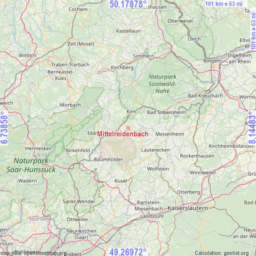
Mittelreidenbach GPS coordinates[2]
49° 43' 34.968" North, 7° 26' 30.12" East
| Map corner | latitude | longitude |
|---|---|---|
| Upper-left | 50.17878°, | 6.73858° |
| Center: | 49.72638°, | 7.4417° |
| Lower-right: | 49.26972°, | 8.14483° |
| Map W x H: | 101.1×101.1 km | = 62.8×62.8mi |
| max Lat: | 55.01917° ⇑70.7% North |
| Mittelreidenbach: | 49.72638° |
| min Lat: | ⇓29.3% South 47.40724° |
| min Long | Mittelreidenbac | max Long |
| 5.92978° | 7.4417° | 14.98853° |
| W 12%⇐ | ⇒88% E |
Elevation
Elevation of Mittelreidenbach is 271 m = 889 ft, and this is 21.9 m = 72 ft above average elevation for this country.
| Max E: |
1256 m = 4121 ft | 43.1% |
| Mittelreidenbach | 271 m 889 ft | |
| Avg. | 249.1 m = 817 ft | |
Min E: |
-5 m = -16 ft | 56.9% |
See also: Germany elevation on elevation.city.
Geographical zone
Mittelreidenbach is located in North temperate zone (between Tropic of Cancer and the Arctic Circle). Distance of this North polar circle is 1872.1 km =1163.3 mi to North.| Distance of | km | miles | from Mittelreidenbach |
|---|---|---|---|
| North Pole | 4478 | 2782.5 | to North |
| Arctic Circle | 1872.1 | 1163.3 | to North |
| Tropic Cancer | 2923.1 | 1816.3 | to South |
| Equator | 5529.1 | 3435.6 | to South |


Nearby cities:
15 places around Mittelreidenbach: (largest is in red/bold)
• Bergen
6.6 km =4.1 mi,  344°
344°
• Bärenbach
2.7 km =1.7 mi,  12°
12°
• Dickesbach
2.1 km =1.3 mi,  239°
239°
• Fischbach
3.1 km =1.9 mi,  284°
284°
• Hintertiefenbach
6.6 km =4.1 mi, 276°
• Hoppstädten
7.2 km =4.5 mi,  114°
114°
• Kirn
7.1 km =4.4 mi, 9°
• Limbach
7.8 km =4.8 mi,  84°
84°
• Meckenbach
7.6 km =4.7 mi,  33°
33°
• Oberreidenbach
2.6 km =1.6 mi,  147°
147°
• Otzweiler
5.5 km =3.4 mi,  101°
101°
• Schmidthachenbach
2 km =1.2 mi,  66°
66°
• Sien
5.7 km =3.5 mi,  128°
128°
• Sienhachenbach
4.2 km =2.6 mi, 134°
• Unterjeckenbach
7.3 km =4.5 mi,  155°
155°
Sources, notices
• [Note1] Compared only with cities in Germany existing in our database
• [Src1] Map data: © OpenStreetMap contributors (CC-BY-SA)
• [Src2] Other city data from geonames.org with taken over terms of usage.
• [Src3] Geographical zone / Annual Mean Temperature by Robert A. Rohde @ Wikipedia
