Sien geodata
Sien (Rheinland-Pfalz) is a seat of a fourth-order administrative division; located in Germany in Europe/Berlin (GMT+2) time zone. With population of 611 people, there are 8760 cities with bigger population in this country. Compared to other cities in Germany, 71.6% of cities are located further ↑North; 86.9% of cities are located further →East and 67.4% of cities have lower elevation than Sien. Note1


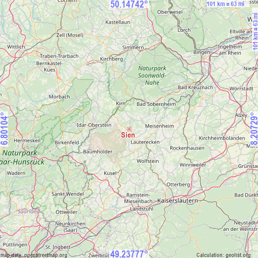
Sien GPS coordinates[2]
49° 41' 40.992" North, 7° 30' 14.976" East
| Map corner | latitude | longitude |
|---|---|---|
| Upper-left | 50.14742°, | 6.80104° |
| Center: | 49.69472°, | 7.50416° |
| Lower-right: | 49.23777°, | 8.20729° |
| Map W x H: | 101.1×101.1 km | = 62.8×62.8mi |
| max Lat: | 55.01917° ⇑71.6% North |
| Sien: | 49.69472° |
| min Lat: | ⇓28.4% South 47.40724° |
| min Long | Sien | max Long |
| 5.92978° | 7.50416° | 14.98853° |
| W 13.1%⇐ | ⇒86.9% E |
Elevation
Elevation of Sien is 338 m = 1109 ft, and this is 88.9 m = 292 ft above average elevation for this country.
| Max E: |
1256 m = 4121 ft | 32.6% |
| Sien | 338 m 1109 ft | |
| Avg. | 249.1 m = 817 ft | |
Min E: |
-5 m = -16 ft | 67.4% |
See also: Germany elevation on elevation.city.
Geographical zone
Sien is located in North temperate zone (between Tropic of Cancer and the Arctic Circle). Distance of this North polar circle is 1875.6 km =1165.4 mi to North.| Distance of | km | miles | from Sien |
|---|---|---|---|
| North Pole | 4481.5 | 2784.7 | to North |
| Arctic Circle | 1875.6 | 1165.4 | to North |
| Tropic Cancer | 2919.6 | 1814.2 | to South |
| Equator | 5525.5 | 3433.4 | to South |


Nearby cities:
15 places around Sien: (largest is in red/bold)
• Herren-Sulzbach
5.4 km =3.4 mi,  157°
157°
• Homberg
5.1 km =3.2 mi,  169°
169°
• Hoppstädten
2.2 km =1.4 mi,  74°
74°
• Hundsbach
4.1 km =2.5 mi,  53°
53°
• Kappeln
4.7 km =2.9 mi,  105°
105°
• Langweiler
3.2 km =2 mi, 163°
• Limbach
5.4 km =3.4 mi,  37°
37°
• Merzweiler
3.8 km =2.4 mi,  146°
146°
• Mittelreidenbach
5.7 km =3.5 mi,  308°
308°
• Oberreidenbach
3.4 km =2.1 mi,  293°
293°
• Otzweiler
2.6 km =1.6 mi,  20°
20°
• Schmidthachenbach
5.1 km =3.2 mi,  327°
327°
• Schweinschied
4.5 km =2.8 mi,  82°
82°
• Sienhachenbach
1.6 km =1 mi, 291°
• Unterjeckenbach
3.5 km =2.2 mi,  205°
205°
Sources, notices
• [Note1] Compared only with cities in Germany existing in our database
• [Src1] Map data: © OpenStreetMap contributors (CC-BY-SA)
• [Src2] Other city data from geonames.org with taken over terms of usage.
• [Src3] Geographical zone / Annual Mean Temperature by Robert A. Rohde @ Wikipedia
