Schnakenbek geodata
Schnakenbek (Schleswig-Holstein) is a seat of a fourth-order administrative division; located in Germany in Europe/Berlin (GMT+2) time zone. With population of 868 people, there are 7635 cities with bigger population in this country. Compared to other cities in Germany, 84.4% of cities are located further ↓South; 58.9% of cities are located further ←West and 87% of cities have higher elevation than Schnakenbek. Note1
Administrative division(s):
- Level 1: Schleswig-Holstein
- Level 3: Kreis Herzogtum Lauenburg
- Level 4: Schnakenbek


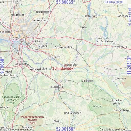
Schnakenbek GPS coordinates[2]
53° 22' 59.988" North, 10° 30' 0" East
| Map corner | latitude | longitude |
|---|---|---|
| Upper-left | 53.80065°, | 9.79688° |
| Center: | 53.38333°, | 10.5° |
| Lower-right: | 52.96188°, | 11.20313° |
| Map W x H: | 93.3×93.3 km | = 58×58mi |
| max Lat: | 55.01917° ⇑15.6% North |
| Schnakenbek: | 53.38333° |
| min Lat: | ⇓84.4% South 47.40724° |
| min Long | Schnakenbek | max Long |
| 5.92978° | 10.5° | 14.98853° |
| W 58.9%⇐ | ⇒41.1% E |
Elevation
Elevation of Schnakenbek is 30 m = 98 ft, and this is 219.1 m = 719 ft below average elevation for this country.
| Max E: |
1256 m = 4121 ft | 87% |
| Avg. | 249.1 m = 817 ft | |
| Schnakenbek | 30 m = 98 ft | |
Min E: |
-5 m = -16 ft | 13% |
See also: Germany elevation on elevation.city.
Geographical zone
Schnakenbek is located in North temperate zone (between Tropic of Cancer and the Arctic Circle). Distance of this North polar circle is 1465.5 km =910.6 mi to North.| Distance of | km | miles | from Schnakenbek |
|---|---|---|---|
| North Pole | 4071.4 | 2529.8 | to North |
| Arctic Circle | 1465.5 | 910.6 | to North |
| Tropic Cancer | 3329.8 | 2069 | to South |
| Equator | 5935.7 | 3688.3 | to South |


Nearby cities:
15 places around Schnakenbek: (largest is in red/bold)
• Artlenburg
1.5 km =0.9 mi,  212°
212°
• Basedow
6.7 km =4.2 mi,  56°
56°
• Brietlingen
6.5 km =4 mi, 210°
• Buchhorst
4.4 km =2.7 mi,  86°
86°
• Echem
6 km =3.7 mi,  158°
158°
• Gülzow
7.4 km =4.6 mi,  0°
0°
• Hittbergen
7.3 km =4.5 mi,  126°
126°
• Juliusburg
3.7 km =2.3 mi, 0°
• Krukow
3.9 km =2.4 mi,  343°
343°
• Krüzen
2.9 km =1.8 mi,  50°
50°
• Lanze
7 km =4.3 mi, 86°
• Lauenburg
4 km =2.5 mi,  108°
108°
• Lütau
6.5 km =4 mi,  30°
30°
• Tespe
6.1 km =3.8 mi,  283°
283°
• Wiershop
6.5 km =4 mi,  329°
329°
Sources, notices
• [Note1] Compared only with cities in Germany existing in our database
• [Src1] Map data: © OpenStreetMap contributors (CC-BY-SA)
• [Src2] Other city data from geonames.org with taken over terms of usage.
• [Src3] Geographical zone / Annual Mean Temperature by Robert A. Rohde @ Wikipedia
