Tespe geodata
Tespe (Lower Saxony) is a seat of a fourth-order administrative division; located in Germany in Europe/Berlin (GMT+2) time zone. With population of 3,987 people, there are 3308 cities with bigger population in this country. Compared to other cities in Germany, 84.5% of cities are located further ↓South; 57.3% of cities are located further ←West and 96.6% of cities have higher elevation than Tespe. Note1


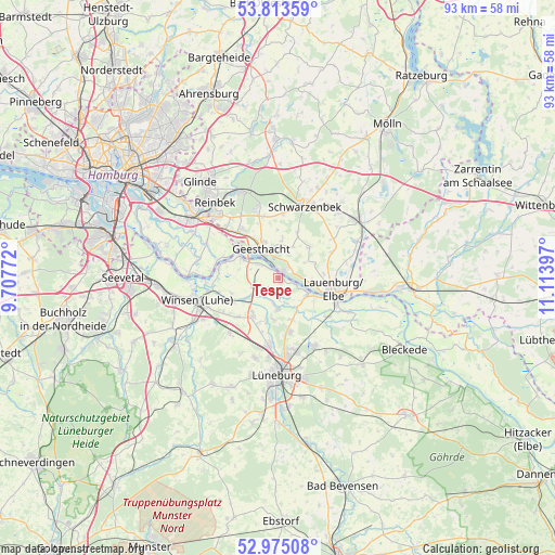
Tespe GPS coordinates[2]
53° 23' 47.04" North, 10° 24' 39.024" East
| Map corner | latitude | longitude |
|---|---|---|
| Upper-left | 53.81359°, | 9.70772° |
| Center: | 53.3964°, | 10.41084° |
| Lower-right: | 52.97508°, | 11.11397° |
| Map W x H: | 93.2×93.2 km | = 57.9×57.9mi |
| max Lat: | 55.01917° ⇑15.5% North |
| Tespe: | 53.3964° |
| min Lat: | ⇓84.5% South 47.40724° |
| min Long | Tespe | max Long |
| 5.92978° | 10.41084° | 14.98853° |
| W 57.3%⇐ | ⇒42.7% E |
Elevation
Elevation of Tespe is 5 m = 16 ft, and this is 244.1 m = 801 ft below average elevation for this country.
| Max E: |
1256 m = 4121 ft | 96.6% |
| Avg. | 249.1 m = 817 ft | |
| Tespe | 5 m = 16 ft | |
Min E: |
-5 m = -16 ft | 3.4% |
See also: Germany elevation on elevation.city.
Geographical zone
Tespe is located in North temperate zone (between Tropic of Cancer and the Arctic Circle). Distance of this North polar circle is 1464.1 km =909.7 mi to North.| Distance of | km | miles | from Tespe |
|---|---|---|---|
| North Pole | 4069.9 | 2528.9 | to North |
| Arctic Circle | 1464.1 | 909.7 | to North |
| Tropic Cancer | 3331.2 | 2069.9 | to South |
| Equator | 5937.1 | 3689.1 | to South |


Nearby cities:
15 places around Tespe: (largest is in red/bold)
• Artlenburg
5.8 km =3.6 mi,  118°
118°
• Barum
5.2 km =3.2 mi,  187°
187°
• Brietlingen
7.5 km =4.7 mi,  159°
159°
• Geesthacht
4.9 km =3 mi,  333°
333°
• Gülzow
8.4 km =5.2 mi,  44°
44°
• Hamwarde
6 km =3.7 mi,  3°
3°
• Handorf
7.5 km =4.7 mi,  214°
214°
• Juliusburg
6.3 km =3.9 mi,  69°
69°
• Krukow
5.3 km =3.3 mi,  64°
64°
• Krüzen
8.1 km =5 mi,  87°
87°
• Marschacht
3.2 km =2 mi,  311°
311°
• Schnakenbek
6.1 km =3.8 mi,  103°
103°
• Wiershop
4.9 km =3 mi,  32°
32°
• Wittorf
7.2 km =4.5 mi, 194°
• Worth
7.8 km =4.8 mi, 2°
Sources, notices
• [Note1] Compared only with cities in Germany existing in our database
• [Src1] Map data: © OpenStreetMap contributors (CC-BY-SA)
• [Src2] Other city data from geonames.org with taken over terms of usage.
• [Src3] Geographical zone / Annual Mean Temperature by Robert A. Rohde @ Wikipedia
