Schieren geodata
Schieren (Schleswig-Holstein) is a seat of a fourth-order administrative division; located in Germany in Europe/Berlin (GMT+2) time zone. With population of 267 people, there are 10178 cities with bigger population in this country. Compared to other cities in Germany, 91.9% of cities are located further ↓South; 57% of cities are located further ←West and 79.9% of cities have higher elevation than Schieren. Note1


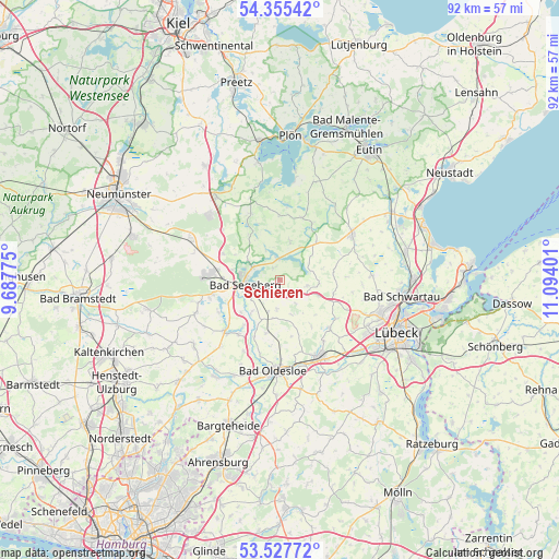
Schieren GPS coordinates[2]
53° 56' 37.032" North, 10° 23' 27.168" East
| Map corner | latitude | longitude |
|---|---|---|
| Upper-left | 54.35542°, | 9.68775° |
| Center: | 53.94362°, | 10.39088° |
| Lower-right: | 53.52772°, | 11.09401° |
| Map W x H: | 92×92 km | = 57.2×57.2mi |
| max Lat: | 55.01917° ⇑8.1% North |
| Schieren: | 53.94362° |
| min Lat: | ⇓91.9% South 47.40724° |
| min Long | Schieren | max Long |
| 5.92978° | 10.39088° | 14.98853° |
| W 57%⇐ | ⇒43% E |
Elevation
Elevation of Schieren is 47 m = 154 ft, and this is 202.1 m = 663 ft below average elevation for this country.
| Max E: |
1256 m = 4121 ft | 79.9% |
| Avg. | 249.1 m = 817 ft | |
| Schieren | 47 m = 154 ft | |
Min E: |
-5 m = -16 ft | 20.1% |
See also: Germany elevation on elevation.city.
Geographical zone
Schieren is located in North temperate zone (between Tropic of Cancer and the Arctic Circle). Distance of this North polar circle is 1403.2 km =871.9 mi to North.| Distance of | km | miles | from Schieren |
|---|---|---|---|
| North Pole | 4009.1 | 2491.1 | to North |
| Arctic Circle | 1403.2 | 871.9 | to North |
| Tropic Cancer | 3392 | 2107.7 | to South |
| Equator | 5998 | 3727 | to South |


Nearby cities:
15 places around Schieren: (largest is in red/bold)
• Bad Segeberg
5.8 km =3.6 mi,  269°
269°
• Bahrenhof
6.7 km =4.2 mi,  184°
184°
• Bühnsdorf
6.7 km =4.2 mi, 184°
• Geschendorf
4.2 km =2.6 mi,  126°
126°
• Groß Rönnau
5.5 km =3.4 mi,  297°
297°
• Klein Gladebrügge
5.7 km =3.5 mi,  238°
238°
• Klein Rönnau
5.5 km =3.4 mi, 297°
• Neuengörs
4.9 km =3 mi,  185°
185°
• Pronstorf
5 km =3.1 mi,  81°
81°
• Stipsdorf
3.8 km =2.4 mi,  280°
280°
• Strukdorf
6.8 km =4.2 mi,  116°
116°
• Traventhal
6.9 km =4.3 mi,  225°
225°
• Weede
2.7 km =1.7 mi,  209°
209°
• Wensin
4.7 km =2.9 mi,  20°
20°
• Westerrade
4 km =2.5 mi,  106°
106°
Sources, notices
• [Note1] Compared only with cities in Germany existing in our database
• [Src1] Map data: © OpenStreetMap contributors (CC-BY-SA)
• [Src2] Other city data from geonames.org with taken over terms of usage.
• [Src3] Geographical zone / Annual Mean Temperature by Robert A. Rohde @ Wikipedia
