Weede geodata
Weede (Schleswig-Holstein) is a seat of a fourth-order administrative division; located in Germany in Europe/Berlin (GMT+2) time zone. With population of 992 people, there are 7213 cities with bigger population in this country. Compared to other cities in Germany, 91.6% of cities are located further ↓South; 56.8% of cities are located further ←West and 82.8% of cities have higher elevation than Weede. Note1


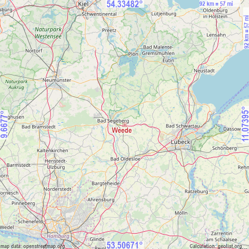
Weede GPS coordinates[2]
53° 55' 22.152" North, 10° 22' 14.952" East
| Map corner | latitude | longitude |
|---|---|---|
| Upper-left | 54.33482°, | 9.6677° |
| Center: | 53.92282°, | 10.37082° |
| Lower-right: | 53.50671°, | 11.07395° |
| Map W x H: | 92.1×92.1 km | = 57.2×57.2mi |
| max Lat: | 55.01917° ⇑8.4% North |
| Weede: | 53.92282° |
| min Lat: | ⇓91.6% South 47.40724° |
| min Long | Weede | max Long |
| 5.92978° | 10.37082° | 14.98853° |
| W 56.8%⇐ | ⇒43.2% E |
Elevation
Elevation of Weede is 40 m = 131 ft, and this is 209.1 m = 686 ft below average elevation for this country.
| Max E: |
1256 m = 4121 ft | 82.8% |
| Avg. | 249.1 m = 817 ft | |
| Weede | 40 m = 131 ft | |
Min E: |
-5 m = -16 ft | 17.2% |
See also: Germany elevation on elevation.city.
Geographical zone
Weede is located in North temperate zone (between Tropic of Cancer and the Arctic Circle). Distance of this North polar circle is 1405.5 km =873.3 mi to North.| Distance of | km | miles | from Weede |
|---|---|---|---|
| North Pole | 4011.4 | 2492.6 | to North |
| Arctic Circle | 1405.5 | 873.3 | to North |
| Tropic Cancer | 3389.7 | 2106.3 | to South |
| Equator | 5995.7 | 3725.6 | to South |


Nearby cities:
15 places around Weede: (largest is in red/bold)
• Bad Segeberg
5 km =3.1 mi,  296°
296°
• Bahrenhof
4.5 km =2.8 mi,  169°
169°
• Bühnsdorf
4.5 km =2.8 mi, 169°
• Dreggers
4.6 km =2.9 mi,  197°
197°
• Geschendorf
4.7 km =2.9 mi,  92°
92°
• Groß Rönnau
6 km =3.7 mi,  323°
323°
• Högersdorf
5.8 km =3.6 mi,  263°
263°
• Klein Gladebrügge
3.6 km =2.2 mi, 259°
• Klein Rönnau
6 km =3.7 mi, 323°
• Neuengörs
2.7 km =1.7 mi,  162°
162°
• Schieren
2.7 km =1.7 mi,  29°
29°
• Schwissel
5.3 km =3.3 mi,  241°
241°
• Stipsdorf
3.9 km =2.4 mi, 320°
• Traventhal
4.4 km =2.7 mi,  234°
234°
• Westerrade
5.3 km =3.3 mi,  77°
77°
Sources, notices
• [Note1] Compared only with cities in Germany existing in our database
• [Src1] Map data: © OpenStreetMap contributors (CC-BY-SA)
• [Src2] Other city data from geonames.org with taken over terms of usage.
• [Src3] Geographical zone / Annual Mean Temperature by Robert A. Rohde @ Wikipedia
