Geschendorf geodata
Geschendorf (Schleswig-Holstein) is a seat of a fourth-order administrative division; located in Germany in Europe/Berlin (GMT+2) time zone. With population of 493 people, there are 9401 cities with bigger population in this country. Compared to other cities in Germany, 91.6% of cities are located further ↓South; 57.9% of cities are located further ←West and 81.4% of cities have higher elevation than Geschendorf. Note1
Administrative division(s):
- Level 1: Schleswig-Holstein
- Level 3: Kreis Segeberg
- Level 4: Geschendorf


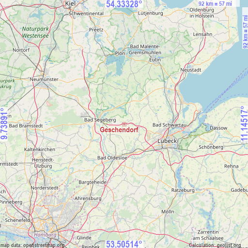
Geschendorf GPS coordinates[2]
53° 55' 16.536" North, 10° 26' 31.344" East
| Map corner | latitude | longitude |
|---|---|---|
| Upper-left | 54.33328°, | 9.73891° |
| Center: | 53.92126°, | 10.44204° |
| Lower-right: | 53.50514°, | 11.14517° |
| Map W x H: | 92.1×92.1 km | = 57.2×57.2mi |
| max Lat: | 55.01917° ⇑8.4% North |
| Geschendorf: | 53.92126° |
| min Lat: | ⇓91.6% South 47.40724° |
| min Long | Geschendorf | max Long |
| 5.92978° | 10.44204° | 14.98853° |
| W 57.9%⇐ | ⇒42.1% E |
Elevation
Elevation of Geschendorf is 43 m = 141 ft, and this is 206.1 m = 676 ft below average elevation for this country.
| Max E: |
1256 m = 4121 ft | 81.4% |
| Avg. | 249.1 m = 817 ft | |
| Geschendorf | 43 m = 141 ft | |
Min E: |
-5 m = -16 ft | 18.6% |
See also: Germany elevation on elevation.city.
Geographical zone
Geschendorf is located in North temperate zone (between Tropic of Cancer and the Arctic Circle). Distance of this North polar circle is 1405.7 km =873.5 mi to North.| Distance of | km | miles | from Geschendorf |
|---|---|---|---|
| North Pole | 4011.6 | 2492.7 | to North |
| Arctic Circle | 1405.7 | 873.5 | to North |
| Tropic Cancer | 3389.6 | 2106.2 | to South |
| Equator | 5995.5 | 3725.4 | to South |


Nearby cities:
15 places around Geschendorf: (largest is in red/bold)
• Bahrenhof
5.7 km =3.5 mi,  222°
222°
• Bühnsdorf
5.7 km =3.5 mi, 222°
• Dreggers
7.4 km =4.6 mi,  235°
235°
• Heilshoop
7.3 km =4.5 mi,  125°
125°
• Mönkhagen
7.5 km =4.7 mi,  108°
108°
• Neuengörs
4.5 km =2.8 mi, 238°
• Pronstorf
3.6 km =2.2 mi,  26°
26°
• Rehhorst
4.5 km =2.8 mi,  159°
159°
• Schieren
4.2 km =2.6 mi,  306°
306°
• Stipsdorf
7.8 km =4.8 mi,  294°
294°
• Strukdorf
2.8 km =1.7 mi,  100°
100°
• Weede
4.7 km =2.9 mi,  272°
272°
• Wensin
7.1 km =4.4 mi,  346°
346°
• Westerrade
1.4 km =0.9 mi,  21°
21°
• Zarpen
7.8 km =4.8 mi,  141°
141°
Sources, notices
• [Note1] Compared only with cities in Germany existing in our database
• [Src1] Map data: © OpenStreetMap contributors (CC-BY-SA)
• [Src2] Other city data from geonames.org with taken over terms of usage.
• [Src3] Geographical zone / Annual Mean Temperature by Robert A. Rohde @ Wikipedia
