Boren geodata
Boren (Schleswig-Holstein) is a populated place; located in Germany in Europe/Berlin (GMT+2) time zone. With population of 834 people, there are 7762 cities with bigger population in this country. Compared to other cities in Germany, 98.6% of cities are located further ↓South; 52.4% of cities are located further →East and 90.1% of cities have higher elevation than Boren. Note1
Administrative division(s):
- Level 1: Schleswig-Holstein
- Level 3: Kreis Schleswig-Flensburg
- Level 4: Boren


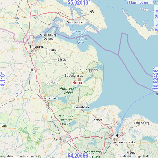
Boren GPS coordinates[2]
54° 36' 54.216" North, 9° 49' 16.068" East
| Map corner | latitude | longitude |
|---|---|---|
| Upper-left | 55.02018°, | 9.118° |
| Center: | 54.61506°, | 9.82113° |
| Lower-right: | 54.20586°, | 10.52426° |
| Map W x H: | 90.5×90.5 km | = 56.2×56.2mi |
| max Lat: | 55.01917° ⇑1.4% North |
| Boren: | 54.61506° |
| min Lat: | ⇓98.6% South 47.40724° |
| min Long | Boren | max Long |
| 5.92978° | 9.82113° | 14.98853° |
| W 47.6%⇐ | ⇒52.4% E |
Elevation
Elevation of Boren is 21 m = 69 ft, and this is 228.1 m = 748 ft below average elevation for this country.
| Max E: |
1256 m = 4121 ft | 90.1% |
| Avg. | 249.1 m = 817 ft | |
| Boren | 21 m = 69 ft | |
Min E: |
-5 m = -16 ft | 9.9% |
See also: Germany elevation on elevation.city.
Geographical zone
Boren is located in North temperate zone (between Tropic of Cancer and the Arctic Circle). Distance of this North polar circle is 1328.5 km =825.5 mi to North.| Distance of | km | miles | from Boren |
|---|---|---|---|
| North Pole | 3934.4 | 2444.7 | to North |
| Arctic Circle | 1328.5 | 825.5 | to North |
| Tropic Cancer | 3466.7 | 2154.1 | to South |
| Equator | 6072.6 | 3773.3 | to South |


Nearby cities:
15 places around Boren: (largest is in red/bold)
• Brebel
5 km =3.1 mi,  293°
293°
• Dollrottfeld
2.1 km =1.3 mi,  351°
351°
• Grödersby
6.5 km =4 mi,  71°
71°
• Norderbrarup
5.5 km =3.4 mi,  321°
321°
• Nottfeld
3.5 km =2.2 mi,  272°
272°
• Oersberg
6 km =3.7 mi,  17°
17°
• Rabenkirchen-Faulück
2.8 km =1.7 mi,  42°
42°
• Saustrup
6.7 km =4.2 mi,  328°
328°
• Scheggerott
5.7 km =3.5 mi,  357°
357°
• Steinfeld
4.9 km =3 mi,  249°
249°
• Süderbrarup
3.2 km =2 mi,  309°
309°
• Thumby
7.1 km =4.4 mi,  119°
119°
• Ulsnis
7.1 km =4.4 mi,  220°
220°
• Wagersrott
5.9 km =3.7 mi, 346°
• Winnemark
6.2 km =3.9 mi,  88°
88°
Sources, notices
• [Note1] Compared only with cities in Germany existing in our database
• [Src1] Map data: © OpenStreetMap contributors (CC-BY-SA)
• [Src2] Other city data from geonames.org with taken over terms of usage.
• [Src3] Geographical zone / Annual Mean Temperature by Robert A. Rohde @ Wikipedia
