Schaalby geodata
Schaalby (Schleswig-Holstein) is a seat of a fourth-order administrative division; located in Germany in Europe/Berlin (GMT+2) time zone. With population of 1,700 people, there are 5512 cities with bigger population in this country. Compared to other cities in Germany, 98.3% of cities are located further ↓South; 55.6% of cities are located further →East and 89.7% of cities have higher elevation than Schaalby. Note1
Administrative division(s):
- Level 1: Schleswig-Holstein
- Level 3: Kreis Schleswig-Flensburg
- Level 4: Schaalby


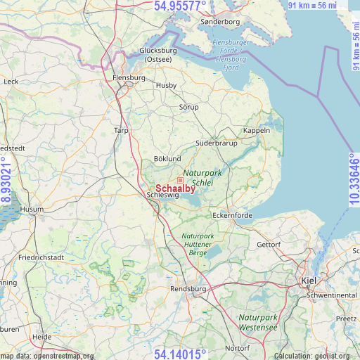
Schaalby GPS coordinates[2]
54° 33' 0" North, 9° 37' 59.988" East
| Map corner | latitude | longitude |
|---|---|---|
| Upper-left | 54.95577°, | 8.93021° |
| Center: | 54.55°, | 9.63333° |
| Lower-right: | 54.14015°, | 10.33646° |
| Map W x H: | 90.7×90.7 km | = 56.4×56.4mi |
| max Lat: | 55.01917° ⇑1.7% North |
| Schaalby: | 54.55° |
| min Lat: | ⇓98.3% South 47.40724° |
| min Long | Schaalby | max Long |
| 5.92978° | 9.63333° | 14.98853° |
| W 44.4%⇐ | ⇒55.6% E |
Elevation
Elevation of Schaalby is 22 m = 72 ft, and this is 227.1 m = 745 ft below average elevation for this country.
| Max E: |
1256 m = 4121 ft | 89.7% |
| Avg. | 249.1 m = 817 ft | |
| Schaalby | 22 m = 72 ft | |
Min E: |
-5 m = -16 ft | 10.3% |
See also: Germany elevation on elevation.city.
Geographical zone
Schaalby is located in North temperate zone (between Tropic of Cancer and the Arctic Circle). Distance of this North polar circle is 1335.8 km =830 mi to North.| Distance of | km | miles | from Schaalby |
|---|---|---|---|
| North Pole | 3941.7 | 2449.3 | to North |
| Arctic Circle | 1335.8 | 830 | to North |
| Tropic Cancer | 3459.5 | 2149.6 | to South |
| Equator | 6065.4 | 3768.9 | to South |


Nearby cities:
15 places around Schaalby: (largest is in red/bold)
• Borgwedel
6 km =3.7 mi,  158°
158°
• Brodersby
5.7 km =3.5 mi,  109°
109°
• Böklund
6.4 km =4 mi,  329°
329°
• Fahrdorf
6 km =3.7 mi,  201°
201°
• Goltoft
5.4 km =3.4 mi,  90°
90°
• Güby
7.7 km =4.8 mi, 163°
• Neuberend
6.4 km =4 mi,  270°
270°
• Nübel
3.7 km =2.3 mi,  299°
299°
• Schleswig
5.8 km =3.6 mi,  236°
236°
• Stolk
7.7 km =4.8 mi,  315°
315°
• Süderfahrenstedt
4.9 km =3 mi, 318°
• Taarstedt
3.7 km =2.3 mi,  60°
60°
• Tolk
3.3 km =2.1 mi,  5°
5°
• Twedt
6.4 km =4 mi,  30°
30°
• Ulsnis
7.7 km =4.8 mi,  76°
76°
Sources, notices
• [Note1] Compared only with cities in Germany existing in our database
• [Src1] Map data: © OpenStreetMap contributors (CC-BY-SA)
• [Src2] Other city data from geonames.org with taken over terms of usage.
• [Src3] Geographical zone / Annual Mean Temperature by Robert A. Rohde @ Wikipedia
