Sahms geodata
Sahms (Schleswig-Holstein) is a seat of a fourth-order administrative division; located in Germany in Europe/Berlin (GMT+2) time zone. With population of 371 people, there are 9785 cities with bigger population in this country. Compared to other cities in Germany, 85.8% of cities are located further ↓South; 59.4% of cities are located further ←West and 85.4% of cities have higher elevation than Sahms. Note1
Administrative division(s):
- Level 1: Schleswig-Holstein
- Level 3: Kreis Herzogtum Lauenburg
- Level 4: Sahms


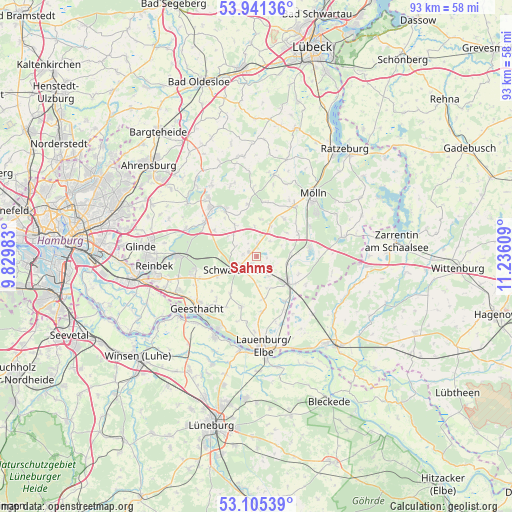
Sahms GPS coordinates[2]
53° 31' 31.584" North, 10° 31' 58.656" East
| Map corner | latitude | longitude |
|---|---|---|
| Upper-left | 53.94136°, | 9.82983° |
| Center: | 53.52544°, | 10.53296° |
| Lower-right: | 53.10539°, | 11.23609° |
| Map W x H: | 93×93 km | = 57.8×57.8mi |
| max Lat: | 55.01917° ⇑14.2% North |
| Sahms: | 53.52544° |
| min Lat: | ⇓85.8% South 47.40724° |
| min Long | Sahms | max Long |
| 5.92978° | 10.53296° | 14.98853° |
| W 59.4%⇐ | ⇒40.6% E |
Elevation
Elevation of Sahms is 34 m = 112 ft, and this is 215.1 m = 706 ft below average elevation for this country.
| Max E: |
1256 m = 4121 ft | 85.4% |
| Avg. | 249.1 m = 817 ft | |
| Sahms | 34 m = 112 ft | |
Min E: |
-5 m = -16 ft | 14.6% |
See also: Germany elevation on elevation.city.
Geographical zone
Sahms is located in North temperate zone (between Tropic of Cancer and the Arctic Circle). Distance of this North polar circle is 1449.7 km =900.8 mi to North.| Distance of | km | miles | from Sahms |
|---|---|---|---|
| North Pole | 4055.6 | 2520 | to North |
| Arctic Circle | 1449.7 | 900.8 | to North |
| Tropic Cancer | 3345.6 | 2078.9 | to South |
| Equator | 5951.5 | 3698.1 | to South |


Nearby cities:
15 places around Sahms: (largest is in red/bold)
• Elmenhorst
2.2 km =1.4 mi,  3°
3°
• Fuhlenhagen
5.3 km =3.3 mi,  356°
356°
• Grabau
1.6 km =1 mi,  212°
212°
• Grove
3.4 km =2.1 mi,  284°
284°
• Groß Pampau
2 km =1.2 mi,  100°
100°
• Havekost
5.2 km =3.2 mi,  301°
301°
• Kankelau
3.5 km =2.2 mi,  39°
39°
• Klein Pampau
4 km =2.5 mi,  111°
111°
• Müssen
4.2 km =2.6 mi,  150°
150°
• Roseburg
6.2 km =3.9 mi,  85°
85°
• Schulendorf
6.1 km =3.8 mi,  162°
162°
• Schwarzenbek
4.3 km =2.7 mi,  234°
234°
• Siebeneichen
5.9 km =3.7 mi, 106°
• Talkau
6.1 km =3.8 mi,  24°
24°
• Tramm
6.8 km =4.2 mi,  50°
50°
Sources, notices
• [Note1] Compared only with cities in Germany existing in our database
• [Src1] Map data: © OpenStreetMap contributors (CC-BY-SA)
• [Src2] Other city data from geonames.org with taken over terms of usage.
• [Src3] Geographical zone / Annual Mean Temperature by Robert A. Rohde @ Wikipedia
