Ruschberg geodata
Ruschberg (Rheinland-Pfalz) is a seat of a fourth-order administrative division; located in Germany in Europe/Berlin (GMT+2) time zone. With population of 857 people, there are 7679 cities with bigger population in this country. Compared to other cities in Germany, 73.3% of cities are located further ↑North; 90.1% of cities are located further →East and 77% of cities have lower elevation than Ruschberg. Note1
Administrative division(s):
- Level 1: Rheinland-Pfalz
- Level 3: Landkreis Birkenfeld
- Level 4: Ruschberg


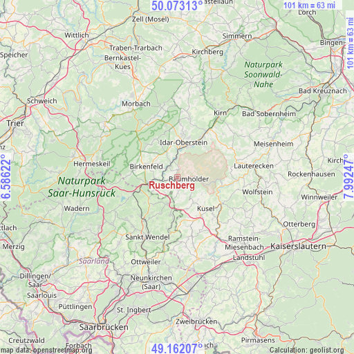
Ruschberg GPS coordinates[2]
49° 37' 11.028" North, 7° 17' 21.624" East
| Map corner | latitude | longitude |
|---|---|---|
| Upper-left | 50.07313°, | 6.58622° |
| Center: | 49.61973°, | 7.28934° |
| Lower-right: | 49.16207°, | 7.99247° |
| Map W x H: | 101.3×101.3 km | = 62.9×62.9mi |
| max Lat: | 55.01917° ⇑73.3% North |
| Ruschberg: | 49.61973° |
| min Lat: | ⇓26.7% South 47.40724° |
| min Long | Ruschberg | max Long |
| 5.92978° | 7.28934° | 14.98853° |
| W 9.9%⇐ | ⇒90.1% E |
Elevation
Elevation of Ruschberg is 412 m = 1352 ft, and this is 162.9 m = 534 ft above average elevation for this country.
| Max E: |
1256 m = 4121 ft | 23% |
| Ruschberg | 412 m 1352 ft | |
| Avg. | 249.1 m = 817 ft | |
Min E: |
-5 m = -16 ft | 77% |
See also: Germany elevation on elevation.city.
Geographical zone
Ruschberg is located in North temperate zone (between Tropic of Cancer and the Arctic Circle). Distance of this North polar circle is 1884 km =1170.7 mi to North.| Distance of | km | miles | from Ruschberg |
|---|---|---|---|
| North Pole | 4489.9 | 2789.9 | to North |
| Arctic Circle | 1884 | 1170.7 | to North |
| Tropic Cancer | 2911.3 | 1809 | to South |
| Equator | 5517.2 | 3428.2 | to South |


Nearby cities:
15 places around Ruschberg: (largest is in red/bold)
• Baumholder
3.2 km =2 mi,  94°
94°
• Berglangenbach
3.6 km =2.2 mi,  232°
232°
• Eckersweiler
5.9 km =3.7 mi,  184°
184°
• Fohren-Linden
4.1 km =2.5 mi,  186°
186°
• Frauenberg
5.2 km =3.2 mi,  355°
355°
• Heimbach
2.9 km =1.8 mi,  263°
263°
• Hoppstädten-Weiersbach
6.4 km =4 mi,  266°
266°
• Kronweiler
3.7 km =2.3 mi,  334°
334°
• Mettweiler
4.5 km =2.8 mi,  154°
154°
• Nohen
3.2 km =2 mi,  298°
298°
• Reichenbach
2.3 km =1.4 mi, 355°
• Rimsberg
6.2 km =3.9 mi, 302°
• Rohrbach
4.4 km =2.7 mi,  201°
201°
• Rückweiler
5.7 km =3.5 mi,  224°
224°
• Sonnenberg-Winnenberg
5.2 km =3.2 mi, 355°
Sources, notices
• [Note1] Compared only with cities in Germany existing in our database
• [Src1] Map data: © OpenStreetMap contributors (CC-BY-SA)
• [Src2] Other city data from geonames.org with taken over terms of usage.
• [Src3] Geographical zone / Annual Mean Temperature by Robert A. Rohde @ Wikipedia
