Rosendorf geodata
Rosendorf (Thuringia) is a seat of a fourth-order administrative division; located in Germany in Europe/Berlin (GMT+2) time zone. With population of 179 people, there are 10562 cities with bigger population in this country. Compared to other cities in Germany, 53.5% of cities are located further ↓South; 78.6% of cities are located further ←West and 73.2% of cities have lower elevation than Rosendorf. Note1


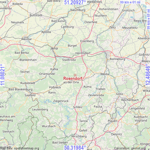
Rosendorf GPS coordinates[2]
50° 46' 0.012" North, 11° 46' 59.988" East
| Map corner | latitude | longitude |
|---|---|---|
| Upper-left | 51.20927°, | 11.08021° |
| Center: | 50.76667°, | 11.78333° |
| Lower-right: | 50.31984°, | 12.48646° |
| Map W x H: | 98.9×98.9 km | = 61.5×61.5mi |
| max Lat: | 55.01917° ⇑46.5% North |
| Rosendorf: | 50.76667° |
| min Lat: | ⇓53.5% South 47.40724° |
| min Long | Rosendorf | max Long |
| 5.92978° | 11.78333° | 14.98853° |
| W 78.6%⇐ | ⇒21.4% E |
Elevation
Elevation of Rosendorf is 384 m = 1260 ft, and this is 134.9 m = 443 ft above average elevation for this country.
| Max E: |
1256 m = 4121 ft | 26.8% |
| Rosendorf | 384 m 1260 ft | |
| Avg. | 249.1 m = 817 ft | |
Min E: |
-5 m = -16 ft | 73.2% |
See also: Germany elevation on elevation.city.
Geographical zone
Rosendorf is located in North temperate zone (between Tropic of Cancer and the Arctic Circle). Distance of this North polar circle is 1756.4 km =1091.4 mi to North.| Distance of | km | miles | from Rosendorf |
|---|---|---|---|
| North Pole | 4362.3 | 2710.6 | to North |
| Arctic Circle | 1756.4 | 1091.4 | to North |
| Tropic Cancer | 3038.8 | 1888.2 | to South |
| Equator | 5644.7 | 3507.5 | to South |


Nearby cities:
15 places around Rosendorf: (largest is in red/bold)
• Bremsnitz
3.7 km =2.3 mi,  347°
347°
• Dreitzsch
3.9 km =2.4 mi,  162°
162°
• Karlsdorf
3.9 km =2.4 mi,  17°
17°
• Kleinebersdorf
6.6 km =4.1 mi,  32°
32°
• Kospoda
6 km =3.7 mi,  202°
202°
• Lemnitz
6.1 km =3.8 mi,  144°
144°
• Meusebach
6.6 km =4.1 mi,  327°
327°
• Miesitz
5.1 km =3.2 mi, 136°
• Neustadt an der Orla
4.3 km =2.7 mi,  217°
217°
• Rattelsdorf
5.7 km =3.5 mi, 348°
• Renthendorf
5.8 km =3.6 mi,  50°
50°
• Schmieritz
5.7 km =3.5 mi,  168°
168°
• Stanau
4 km =2.5 mi,  297°
297°
• Trockenborn-Wolfersdorf
6.1 km =3.8 mi,  287°
287°
• Weißbach
5.6 km =3.5 mi,  0°
0°
Sources, notices
• [Note1] Compared only with cities in Germany existing in our database
• [Src1] Map data: © OpenStreetMap contributors (CC-BY-SA)
• [Src2] Other city data from geonames.org with taken over terms of usage.
• [Src3] Geographical zone / Annual Mean Temperature by Robert A. Rohde @ Wikipedia
