Rinnthal geodata
Rinnthal (Rheinland-Pfalz) is a seat of a fourth-order administrative division; located in Germany in Europe/Berlin (GMT+2) time zone. With population of 659 people, there are 8516 cities with bigger population in this country. Compared to other cities in Germany, 80.1% of cities are located further ↑North; 78.7% of cities are located further →East and 50.3% of cities have higher elevation than Rinnthal. Note1
Administrative division(s):
- Level 1: Rheinland-Pfalz
- Level 3: Landkreis Südliche Weinstraße
- Level 4: Rinnthal


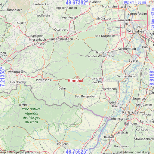
Rinnthal GPS coordinates[2]
49° 13' 0.012" North, 7° 55' 0.012" East
| Map corner | latitude | longitude |
|---|---|---|
| Upper-left | 49.67382°, | 7.21355° |
| Center: | 49.21667°, | 7.91667° |
| Lower-right: | 48.75525°, | 8.6198° |
| Map W x H: | 102.1×102.1 km | = 63.4×63.4mi |
| max Lat: | 55.01917° ⇑80.1% North |
| Rinnthal: | 49.21667° |
| min Lat: | ⇓19.9% South 47.40724° |
| min Long | Rinnthal | max Long |
| 5.92978° | 7.91667° | 14.98853° |
| W 21.3%⇐ | ⇒78.7% E |
Elevation
Elevation of Rinnthal is 223 m = 732 ft, and this is 26.1 m = 86 ft below average elevation for this country.
| Max E: |
1256 m = 4121 ft | 50.3% |
| Avg. | 249.1 m = 817 ft | |
| Rinnthal | 223 m = 732 ft | |
Min E: |
-5 m = -16 ft | 49.7% |
See also: Germany elevation on elevation.city.
Geographical zone
Rinnthal is located in North temperate zone (between Tropic of Cancer and the Arctic Circle). Distance of this North polar circle is 1928.8 km =1198.5 mi to North.| Distance of | km | miles | from Rinnthal |
|---|---|---|---|
| North Pole | 4534.7 | 2817.7 | to North |
| Arctic Circle | 1928.8 | 1198.5 | to North |
| Tropic Cancer | 2866.5 | 1781.2 | to South |
| Equator | 5472.4 | 3400.4 | to South |


Nearby cities:
15 places around Rinnthal: (largest is in red/bold)
• Annweiler am Trifels
4.4 km =2.7 mi,  105°
105°
• Dernbach
7.3 km =4.5 mi,  62°
62°
• Dimbach
5.7 km =3.5 mi,  192°
192°
• Eußerthal
5.2 km =3.2 mi,  44°
44°
• Gossersweiler-Stein
7.5 km =4.7 mi,  170°
170°
• Hauenstein
5.3 km =3.3 mi,  238°
238°
• Lug
3.9 km =2.4 mi,  198°
198°
• Schwanheim
6.1 km =3.8 mi, 203°
• Silz
7.8 km =4.8 mi,  161°
161°
• Spirkelbach
3 km =1.9 mi,  232°
232°
• Völkersweiler
5.7 km =3.5 mi, 167°
• Waldhambach
7.4 km =4.6 mi,  138°
138°
• Waldrohrbach
6.6 km =4.1 mi,  146°
146°
• Wernersberg
3 km =1.9 mi, 164°
• Wilgartswiesen
3.3 km =2.1 mi,  254°
254°
Sources, notices
• [Note1] Compared only with cities in Germany existing in our database
• [Src1] Map data: © OpenStreetMap contributors (CC-BY-SA)
• [Src2] Other city data from geonames.org with taken over terms of usage.
• [Src3] Geographical zone / Annual Mean Temperature by Robert A. Rohde @ Wikipedia
