Dimbach geodata
Dimbach (Rheinland-Pfalz) is a seat of a fourth-order administrative division; located in Germany in Europe/Berlin (GMT+2) time zone. With population of 187 people, there are 10531 cities with bigger population in this country. Compared to other cities in Germany, 80.9% of cities are located further ↑North; 79% of cities are located further →East and 55.3% of cities have lower elevation than Dimbach. Note1


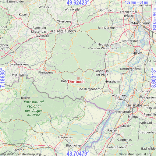
Dimbach GPS coordinates[2]
49° 10' 0.012" North, 7° 54' 0" East
| Map corner | latitude | longitude |
|---|---|---|
| Upper-left | 49.62428°, | 7.19688° |
| Center: | 49.16667°, | 7.9° |
| Lower-right: | 48.70479°, | 8.60313° |
| Map W x H: | 102.2×102.2 km | = 63.5×63.5mi |
| max Lat: | 55.01917° ⇑80.9% North |
| Dimbach: | 49.16667° |
| min Lat: | ⇓19.1% South 47.40724° |
| min Long | Dimbach | max Long |
| 5.92978° | 7.9° | 14.98853° |
| W 21%⇐ | ⇒79% E |
Elevation
Elevation of Dimbach is 260 m = 853 ft, and this is 10.9 m = 36 ft above average elevation for this country.
| Max E: |
1256 m = 4121 ft | 44.7% |
| Dimbach | 260 m 853 ft | |
| Avg. | 249.1 m = 817 ft | |
Min E: |
-5 m = -16 ft | 55.3% |
See also: Germany elevation on elevation.city.
Geographical zone
Dimbach is located in North temperate zone (between Tropic of Cancer and the Arctic Circle). Distance of this North polar circle is 1934.4 km =1202 mi to North.| Distance of | km | miles | from Dimbach |
|---|---|---|---|
| North Pole | 4540.2 | 2821.1 | to North |
| Arctic Circle | 1934.4 | 1202 | to North |
| Tropic Cancer | 2860.9 | 1777.7 | to South |
| Equator | 5466.8 | 3396.9 | to South |


Nearby cities:
15 places around Dimbach: (largest is in red/bold)
• Darstein
2.2 km =1.4 mi,  213°
213°
• Gossersweiler-Stein
3.1 km =1.9 mi,  127°
127°
• Hauenstein
4.3 km =2.7 mi,  310°
310°
• Lug
1.9 km =1.2 mi,  0°
0°
• Münchweiler am Klingbach
5.2 km =3.2 mi,  110°
110°
• Oberschlettenbach
3.1 km =1.9 mi,  221°
221°
• Rinnthal
5.7 km =3.5 mi,  12°
12°
• Schwanheim
1.2 km =0.7 mi,  270°
270°
• Silz
4.1 km =2.5 mi,  117°
117°
• Spirkelbach
3.9 km =2.4 mi,  341°
341°
• Vorderweidenthal
3.9 km =2.4 mi,  198°
198°
• Völkersweiler
2.4 km =1.5 mi,  90°
90°
• Waldrohrbach
4.8 km =3 mi, 90°
• Wernersberg
3.3 km =2.1 mi,  36°
36°
• Wilgartswiesen
5.1 km =3.2 mi, 337°
Sources, notices
• [Note1] Compared only with cities in Germany existing in our database
• [Src1] Map data: © OpenStreetMap contributors (CC-BY-SA)
• [Src2] Other city data from geonames.org with taken over terms of usage.
• [Src3] Geographical zone / Annual Mean Temperature by Robert A. Rohde @ Wikipedia
