Rendsburg geodata
Rendsburg (Schleswig-Holstein) is a seat of a third-order administrative division; located in Germany in Europe/Berlin (GMT+2) time zone. With population of 28,323 people, there are 496 cities with bigger population in this country. Compared to other cities in Germany, 96.4% of cities are located further ↓South; 55.1% of cities are located further →East and 97% of cities have higher elevation than Rendsburg. Note1
Administrative division(s):
- Level 1: Schleswig-Holstein
- Level 3: Kreis Rendsburg-Eckernförde
- Level 4: Rendsburg


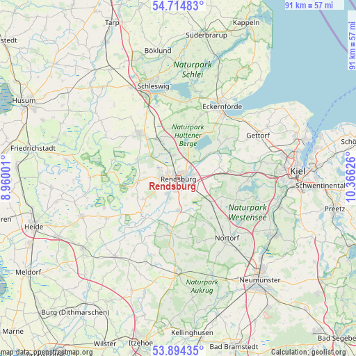
Rendsburg GPS coordinates[2]
54° 18' 23.868" North, 9° 39' 47.268" East
| Map corner | latitude | longitude |
|---|---|---|
| Upper-left | 54.71483°, | 8.96001° |
| Center: | 54.30663°, | 9.66313° |
| Lower-right: | 53.89435°, | 10.36626° |
| Map W x H: | 91.2×91.2 km | = 56.7×56.7mi |
| max Lat: | 55.01917° ⇑3.6% North |
| Rendsburg: | 54.30663° |
| min Lat: | ⇓96.4% South 47.40724° |
| min Long | Rendsburg | max Long |
| 5.92978° | 9.66313° | 14.98853° |
| W 44.9%⇐ | ⇒55.1% E |
Elevation
Elevation of Rendsburg is 4 m = 13 ft, and this is 245.1 m = 804 ft below average elevation for this country.
| Max E: |
1256 m = 4121 ft | 97% |
| Avg. | 249.1 m = 817 ft | |
| Rendsburg | 4 m = 13 ft | |
Min E: |
-5 m = -16 ft | 3% |
See also: Germany elevation on elevation.city.
Geographical zone
Rendsburg is located in North temperate zone (between Tropic of Cancer and the Arctic Circle). Distance of this North polar circle is 1362.8 km =846.8 mi to North.| Distance of | km | miles | from Rendsburg |
|---|---|---|---|
| North Pole | 3968.7 | 2466 | to North |
| Arctic Circle | 1362.8 | 846.8 | to North |
| Tropic Cancer | 3432.4 | 2132.8 | to South |
| Equator | 6038.3 | 3752 | to South |


Nearby cities:
15 places around Rendsburg: (largest is in red/bold)
• Alt Duvenstedt
6.7 km =4.2 mi,  352°
352°
• Borgstedt
4.2 km =2.6 mi,  46°
46°
• Büdelsdorf
1.5 km =0.9 mi,  25°
25°
• Bünsdorf
8.7 km =5.4 mi,  40°
40°
• Fockbek
4.2 km =2.6 mi,  259°
259°
• Jevenstedt
8.2 km =5.1 mi,  178°
178°
• Neu Duvenstedt
6.7 km =4.2 mi,  1°
1°
• Nübbel
5.4 km =3.4 mi,  214°
214°
• Ostenfeld
7.7 km =4.8 mi,  82°
82°
• Osterrönfeld
3 km =1.9 mi,  128°
128°
• Rickert
3 km =1.9 mi, 4°
• Schacht-Audorf
3.5 km =2.2 mi, 78°
• Schülldorf
4.6 km =2.9 mi,  99°
99°
• Schülp
5.7 km =3.5 mi,  201°
201°
• Westerrönfeld
2.7 km =1.7 mi, 198°
Sources, notices
• [Note1] Compared only with cities in Germany existing in our database
• [Src1] Map data: © OpenStreetMap contributors (CC-BY-SA)
• [Src2] Other city data from geonames.org with taken over terms of usage.
• [Src3] Geographical zone / Annual Mean Temperature by Robert A. Rohde @ Wikipedia
