Ostenfeld geodata
Ostenfeld (Schleswig-Holstein) is a populated place; located in Germany in Europe/Berlin (GMT+2) time zone. With population of 625 people, there are 8687 cities with bigger population in this country. Compared to other cities in Germany, 96.4% of cities are located further ↓South; 53.1% of cities are located further →East and 93.9% of cities have higher elevation than Ostenfeld. Note1
Administrative division(s):
- Level 1: Schleswig-Holstein
- Level 3: Kreis Rendsburg-Eckernförde
- Level 4: Ostenfeld (Rendsburg)


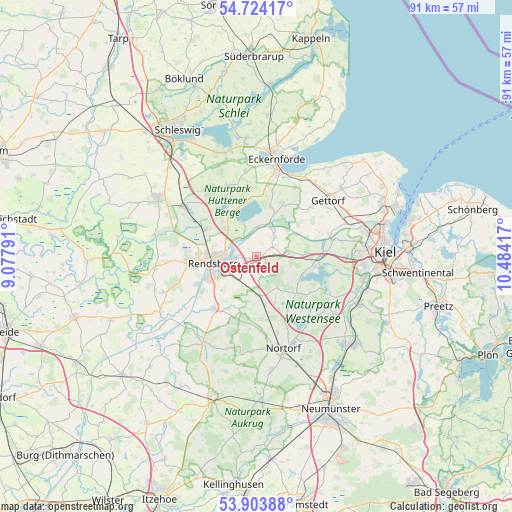
Ostenfeld GPS coordinates[2]
54° 18' 57.852" North, 9° 46' 51.744" East
| Map corner | latitude | longitude |
|---|---|---|
| Upper-left | 54.72417°, | 9.07791° |
| Center: | 54.31607°, | 9.78104° |
| Lower-right: | 53.90388°, | 10.48417° |
| Map W x H: | 91.2×91.2 km | = 56.7×56.7mi |
| max Lat: | 55.01917° ⇑3.6% North |
| Ostenfeld: | 54.31607° |
| min Lat: | ⇓96.4% South 47.40724° |
| min Long | Ostenfeld | max Long |
| 5.92978° | 9.78104° | 14.98853° |
| W 46.9%⇐ | ⇒53.1% E |
Elevation
Elevation of Ostenfeld is 11 m = 36 ft, and this is 238.1 m = 781 ft below average elevation for this country.
| Max E: |
1256 m = 4121 ft | 93.9% |
| Avg. | 249.1 m = 817 ft | |
| Ostenfeld | 11 m = 36 ft | |
Min E: |
-5 m = -16 ft | 6.1% |
See also: Germany elevation on elevation.city.
Geographical zone
Ostenfeld is located in North temperate zone (between Tropic of Cancer and the Arctic Circle). Distance of this North polar circle is 1361.8 km =846.2 mi to North.| Distance of | km | miles | from Ostenfeld |
|---|---|---|---|
| North Pole | 3967.7 | 2465.4 | to North |
| Arctic Circle | 1361.8 | 846.2 | to North |
| Tropic Cancer | 3433.5 | 2133.5 | to South |
| Equator | 6039.4 | 3752.7 | to South |


Nearby cities:
15 places around Ostenfeld: (largest is in red/bold)
• Borgstedt
5 km =3.1 mi,  291°
291°
• Bovenau
3.9 km =2.4 mi,  60°
60°
• Bredenbek
6 km =3.7 mi,  83°
83°
• Büdelsdorf
7 km =4.3 mi,  272°
272°
• Bünsdorf
6 km =3.7 mi,  340°
340°
• Emkendorf
7.1 km =4.4 mi,  140°
140°
• Haßmoor
2.9 km =1.8 mi,  127°
127°
• Klein Wittensee
8.1 km =5 mi, 337°
• Krummwisch
7.9 km =4.9 mi, 76°
• Osterrönfeld
6.1 km =3.8 mi,  241°
241°
• Rendsburg
7.7 km =4.8 mi,  262°
262°
• Rickert
7.7 km =4.8 mi,  284°
284°
• Schacht-Audorf
4.2 km =2.6 mi, 265°
• Schülldorf
3.6 km =2.2 mi, 240°
• Sehestedt
6.1 km =3.8 mi,  22°
22°
Sources, notices
• [Note1] Compared only with cities in Germany existing in our database
• [Src1] Map data: © OpenStreetMap contributors (CC-BY-SA)
• [Src2] Other city data from geonames.org with taken over terms of usage.
• [Src3] Geographical zone / Annual Mean Temperature by Robert A. Rohde @ Wikipedia
