Reinfeld geodata
Reinfeld (Schleswig-Holstein) is a populated place; located in Germany in Europe/Berlin (GMT+2) time zone. With population of 8,340 people, there are 1897 cities with bigger population in this country. Compared to other cities in Germany, 90.4% of cities are located further ↓South; 58.8% of cities are located further ←West and 90.5% of cities have higher elevation than Reinfeld. Note1
Administrative division(s):
- Level 1: Schleswig-Holstein
- Level 3: Kreis Stormarn
- Level 4: Reinfeld (Holstein)


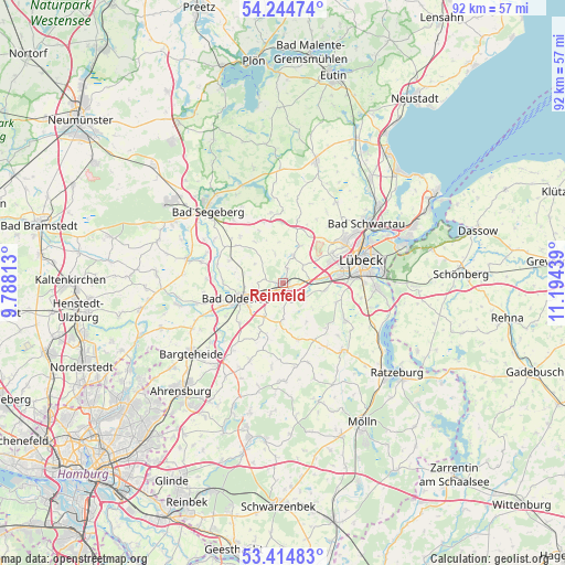
Reinfeld GPS coordinates[2]
53° 49' 54.624" North, 10° 29' 28.536" East
| Map corner | latitude | longitude |
|---|---|---|
| Upper-left | 54.24474°, | 9.78813° |
| Center: | 53.83184°, | 10.49126° |
| Lower-right: | 53.41483°, | 11.19439° |
| Map W x H: | 92.3×92.3 km | = 57.4×57.4mi |
| max Lat: | 55.01917° ⇑9.6% North |
| Reinfeld: | 53.83184° |
| min Lat: | ⇓90.4% South 47.40724° |
| min Long | Reinfeld | max Long |
| 5.92978° | 10.49126° | 14.98853° |
| W 58.8%⇐ | ⇒41.2% E |
Elevation
Elevation of Reinfeld is 20 m = 66 ft, and this is 229.1 m = 752 ft below average elevation for this country.
| Max E: |
1256 m = 4121 ft | 90.5% |
| Avg. | 249.1 m = 817 ft | |
| Reinfeld | 20 m = 66 ft | |
Min E: |
-5 m = -16 ft | 9.5% |
See also: Germany elevation on elevation.city.
Geographical zone
Reinfeld is located in North temperate zone (between Tropic of Cancer and the Arctic Circle). Distance of this North polar circle is 1415.6 km =879.6 mi to North.| Distance of | km | miles | from Reinfeld |
|---|---|---|---|
| North Pole | 4021.5 | 2498.8 | to North |
| Arctic Circle | 1415.6 | 879.6 | to North |
| Tropic Cancer | 3379.6 | 2100 | to South |
| Equator | 5985.5 | 3719.2 | to South |


Nearby cities:
15 places around Reinfeld: (largest is in red/bold)
• Badendorf
6.3 km =3.9 mi,  51°
51°
• Barnitz
3.6 km =2.2 mi,  170°
170°
• Grinau
6.6 km =4.1 mi,  144°
144°
• Groß Schenkenberg
6.1 km =3.8 mi,  125°
125°
• Hamberge
6 km =3.7 mi,  88°
88°
• Heidekamp
2.1 km =1.3 mi,  15°
15°
• Heilshoop
6.4 km =4 mi,  25°
25°
• Klein Wesenberg
4.2 km =2.6 mi,  113°
113°
• Meddewade
4.2 km =2.6 mi,  233°
233°
• Rehhorst
5.9 km =3.7 mi,  344°
344°
• Schürensöhlen
7.3 km =4.5 mi,  184°
184°
• Steinfeld
4.2 km =2.6 mi,  272°
272°
• Wesenberg
3.9 km =2.4 mi, 87°
• Westerau
6.1 km =3.8 mi, 181°
• Zarpen
4.2 km =2.6 mi, 23°
Sources, notices
• [Note1] Compared only with cities in Germany existing in our database
• [Src1] Map data: © OpenStreetMap contributors (CC-BY-SA)
• [Src2] Other city data from geonames.org with taken over terms of usage.
• [Src3] Geographical zone / Annual Mean Temperature by Robert A. Rohde @ Wikipedia
