Badendorf geodata
Badendorf (Schleswig-Holstein) is a seat of a fourth-order administrative division; located in Germany in Europe/Berlin (GMT+2) time zone. With population of 779 people, there are 7985 cities with bigger population in this country. Compared to other cities in Germany, 90.8% of cities are located further ↓South; 60.1% of cities are located further ←West and 89.7% of cities have higher elevation than Badendorf. Note1


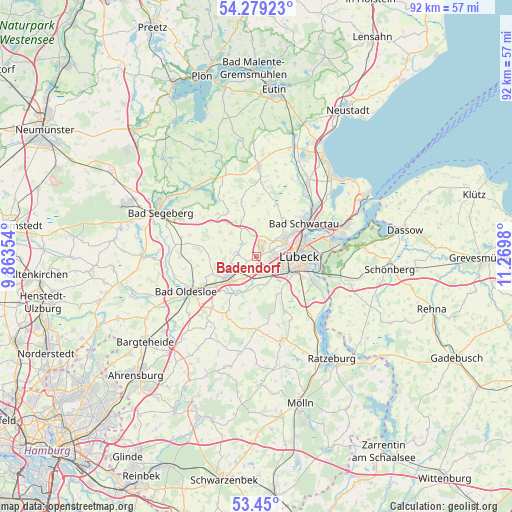
Badendorf GPS coordinates[2]
53° 52' 0.012" North, 10° 34' 0.012" East
| Map corner | latitude | longitude |
|---|---|---|
| Upper-left | 54.27923°, | 9.86354° |
| Center: | 53.86667°, | 10.56667° |
| Lower-right: | 53.45°, | 11.2698° |
| Map W x H: | 92.2×92.2 km | = 57.3×57.3mi |
| max Lat: | 55.01917° ⇑9.2% North |
| Badendorf: | 53.86667° |
| min Lat: | ⇓90.8% South 47.40724° |
| min Long | Badendorf | max Long |
| 5.92978° | 10.56667° | 14.98853° |
| W 60.1%⇐ | ⇒39.9% E |
Elevation
Elevation of Badendorf is 22 m = 72 ft, and this is 227.1 m = 745 ft below average elevation for this country.
| Max E: |
1256 m = 4121 ft | 89.7% |
| Avg. | 249.1 m = 817 ft | |
| Badendorf | 22 m = 72 ft | |
Min E: |
-5 m = -16 ft | 10.3% |
See also: Germany elevation on elevation.city.
Geographical zone
Badendorf is located in North temperate zone (between Tropic of Cancer and the Arctic Circle). Distance of this North polar circle is 1411.8 km =877.3 mi to North.| Distance of | km | miles | from Badendorf |
|---|---|---|---|
| North Pole | 4017.6 | 2496.4 | to North |
| Arctic Circle | 1411.8 | 877.3 | to North |
| Tropic Cancer | 3383.5 | 2102.4 | to South |
| Equator | 5989.4 | 3721.6 | to South |


Nearby cities:
15 places around Badendorf: (largest is in red/bold)
• Barnitz
8.6 km =5.3 mi,  210°
210°
• Grinau
9.3 km =5.8 mi,  186°
186°
• Groß Schenkenberg
7.4 km =4.6 mi,  180°
180°
• Hamberge
3.9 km =2.4 mi,  163°
163°
• Heidekamp
4.7 km =2.9 mi,  247°
247°
• Heilshoop
2.9 km =1.8 mi,  310°
310°
• Klein Wesenberg
5.7 km =3.5 mi, 191°
• Lübeck
7.9 km =4.9 mi,  88°
88°
• Mönkhagen
3.9 km =2.4 mi,  343°
343°
• Rehhorst
6.8 km =4.2 mi,  285°
285°
• Reinfeld
6.3 km =3.9 mi,  231°
231°
• Stockelsdorf
6 km =3.7 mi,  61°
61°
• Strukdorf
7.8 km =4.8 mi,  315°
315°
• Wesenberg
3.9 km =2.4 mi,  196°
196°
• Zarpen
3.3 km =2.1 mi,  270°
270°
Sources, notices
• [Note1] Compared only with cities in Germany existing in our database
• [Src1] Map data: © OpenStreetMap contributors (CC-BY-SA)
• [Src2] Other city data from geonames.org with taken over terms of usage.
• [Src3] Geographical zone / Annual Mean Temperature by Robert A. Rohde @ Wikipedia
