Reifferscheid geodata
Reifferscheid (Rheinland-Pfalz) is a seat of a fourth-order administrative division; located in Germany in Europe/Berlin (GMT+2) time zone. With population of 609 people, there are 8769 cities with bigger population in this country. Compared to other cities in Germany, 54.5% of cities are located further ↑North; 94.6% of cities are located further →East and 90.4% of cities have lower elevation than Reifferscheid. Note1
Administrative division(s):
- Level 1: Rheinland-Pfalz
- Level 3: Landkreis Ahrweiler
- Level 4: Reifferscheid


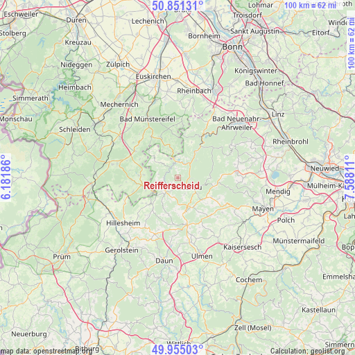
Reifferscheid GPS coordinates[2]
50° 24' 19.044" North, 6° 53' 5.964" East
| Map corner | latitude | longitude |
|---|---|---|
| Upper-left | 50.85131°, | 6.18186° |
| Center: | 50.40529°, | 6.88499° |
| Lower-right: | 49.95503°, | 7.58811° |
| Map W x H: | 99.7×99.7 km | = 62×62mi |
| max Lat: | 55.01917° ⇑54.5% North |
| Reifferscheid: | 50.40529° |
| min Lat: | ⇓45.5% South 47.40724° |
| min Long | Reifferscheid | max Long |
| 5.92978° | 6.88499° | 14.98853° |
| W 5.4%⇐ | ⇒94.6% E |
Elevation
Elevation of Reifferscheid is 518 m = 1699 ft, and this is 268.9 m = 882 ft above average elevation for this country.
| Max E: |
1256 m = 4121 ft | 9.6% |
| Reifferscheid | 518 m 1699 ft | |
| Avg. | 249.1 m = 817 ft | |
Min E: |
-5 m = -16 ft | 90.4% |
See also: Germany elevation on elevation.city.
Geographical zone
Reifferscheid is located in North temperate zone (between Tropic of Cancer and the Arctic Circle). Distance of this North polar circle is 1796.6 km =1116.4 mi to North.| Distance of | km | miles | from Reifferscheid |
|---|---|---|---|
| North Pole | 4402.5 | 2735.6 | to North |
| Arctic Circle | 1796.6 | 1116.4 | to North |
| Tropic Cancer | 2998.6 | 1863.2 | to South |
| Equator | 5604.5 | 3482.5 | to South |


Nearby cities:
15 places around Reifferscheid: (largest is in red/bold)
• Adenau
4.2 km =2.6 mi,  126°
126°
• Antweiler
3.7 km =2.3 mi,  260°
260°
• Barweiler
4.5 km =2.8 mi,  196°
196°
• Dümpelfeld
5.6 km =3.5 mi,  55°
55°
• Eichenbach
5.8 km =3.6 mi,  302°
302°
• Fuchshofen
3.5 km =2.2 mi,  316°
316°
• Harscheid
6.1 km =3.8 mi,  4°
4°
• Honerath
2.7 km =1.7 mi,  156°
156°
• Insul
3.8 km =2.4 mi,  35°
35°
• Leimbach
3 km =1.9 mi,  92°
92°
• Müsch
4.4 km =2.7 mi,  236°
236°
• Schuld
4.7 km =2.9 mi, 3°
• Wimbach
4.8 km =3 mi,  152°
152°
• Winnerath
2.7 km =1.7 mi,  347°
347°
• Wirft
4.5 km =2.8 mi, 196°
Sources, notices
• [Note1] Compared only with cities in Germany existing in our database
• [Src1] Map data: © OpenStreetMap contributors (CC-BY-SA)
• [Src2] Other city data from geonames.org with taken over terms of usage.
• [Src3] Geographical zone / Annual Mean Temperature by Robert A. Rohde @ Wikipedia
