Insul geodata
Insul (Rheinland-Pfalz) is a seat of a fourth-order administrative division; located in Germany in Europe/Berlin (GMT+2) time zone. With population of 473 people, there are 9465 cities with bigger population in this country. Compared to other cities in Germany, 54% of cities are located further ↑North; 94.4% of cities are located further →East and 61.9% of cities have lower elevation than Insul. Note1


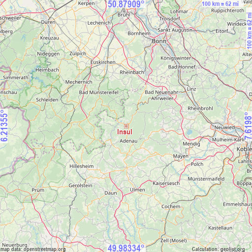
Insul GPS coordinates[2]
50° 25' 59.988" North, 6° 55' 0.012" East
| Map corner | latitude | longitude |
|---|---|---|
| Upper-left | 50.87909°, | 6.21355° |
| Center: | 50.43333°, | 6.91667° |
| Lower-right: | 49.98334°, | 7.6198° |
| Map W x H: | 99.6×99.6 km | = 61.9×61.9mi |
| max Lat: | 55.01917° ⇑54% North |
| Insul: | 50.43333° |
| min Lat: | ⇓46% South 47.40724° |
| min Long | Insul | max Long |
| 5.92978° | 6.91667° | 14.98853° |
| W 5.6%⇐ | ⇒94.4% E |
Elevation
Elevation of Insul is 301 m = 988 ft, and this is 51.9 m = 170 ft above average elevation for this country.
| Max E: |
1256 m = 4121 ft | 38.1% |
| Insul | 301 m 988 ft | |
| Avg. | 249.1 m = 817 ft | |
Min E: |
-5 m = -16 ft | 61.9% |
See also: Germany elevation on elevation.city.
Geographical zone
Insul is located in North temperate zone (between Tropic of Cancer and the Arctic Circle). Distance of this North polar circle is 1793.5 km =1114.4 mi to North.| Distance of | km | miles | from Insul |
|---|---|---|---|
| North Pole | 4399.4 | 2733.7 | to North |
| Arctic Circle | 1793.5 | 1114.4 | to North |
| Tropic Cancer | 3001.7 | 1865.2 | to South |
| Equator | 5607.7 | 3484.5 | to South |


Nearby cities:
15 places around Insul: (largest is in red/bold)
• Adenau
5.8 km =3.6 mi,  168°
168°
• Ahrbrück
7.4 km =4.6 mi,  42°
42°
• Antweiler
7 km =4.3 mi,  237°
237°
• Dümpelfeld
2.4 km =1.5 mi,  90°
90°
• Eichenbach
7.1 km =4.4 mi,  270°
270°
• Fuchshofen
4.7 km =2.9 mi,  263°
263°
• Harscheid
3.4 km =2.1 mi,  329°
329°
• Honerath
5.7 km =3.5 mi,  191°
191°
• Hönningen
4.4 km =2.7 mi,  32°
32°
• Leimbach
3.4 km =2.1 mi, 166°
• Reifferscheid
3.8 km =2.4 mi,  215°
215°
• Schuld
2.5 km =1.6 mi,  309°
309°
• Sierscheid
2.6 km =1.6 mi,  1°
1°
• Wimbach
7.4 km =4.6 mi,  180°
180°
• Winnerath
2.9 km =1.8 mi, 260°
Sources, notices
• [Note1] Compared only with cities in Germany existing in our database
• [Src1] Map data: © OpenStreetMap contributors (CC-BY-SA)
• [Src2] Other city data from geonames.org with taken over terms of usage.
• [Src3] Geographical zone / Annual Mean Temperature by Robert A. Rohde @ Wikipedia
