Raubach geodata
Raubach (Rheinland-Pfalz) is a seat of a fourth-order administrative division; located in Germany in Europe/Berlin (GMT+2) time zone. With population of 1,944 people, there are 5146 cities with bigger population in this country. Compared to other cities in Germany, 51.2% of cities are located further ↑North; 84.5% of cities are located further →East and 50.2% of cities have higher elevation than Raubach. Note1


Raubach GPS coordinates[2]
50° 34' 29.604" North, 7° 37' 29.856" East
| Map corner | latitude | longitude |
|---|---|---|
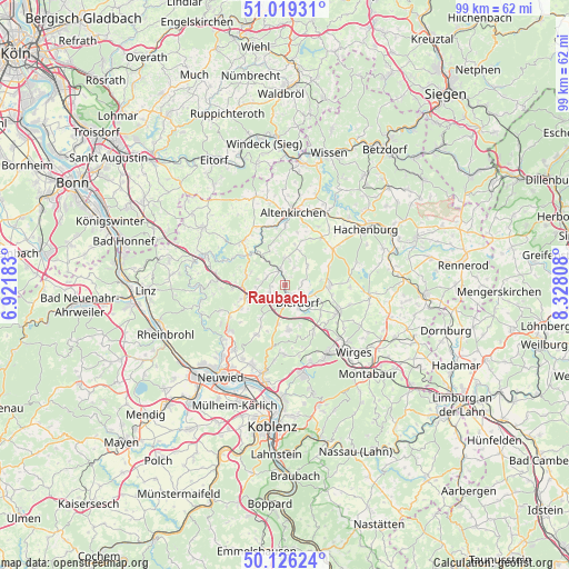
| Upper-left | 51.01931°, | 6.92183° |
| Center: | 50.57489°, | 7.62496° |
| Lower-right: | 50.12624°, | 8.32808° |
| Map W x H: | 99.3×99.3 km | = 61.7×61.7mi |
| max Lat: | 55.01917° ⇑51.2% North |
| Raubach: | 50.57489° |
| min Lat: | ⇓48.8% South 47.40724° |
| min Long | Raubach | max Long |
| 5.92978° | 7.62496° | 14.98853° |
| W 15.5%⇐ | ⇒84.5% E |
Elevation
Elevation of Raubach is 224 m = 735 ft, and this is 25.1 m = 82 ft below average elevation for this country.
| Max E: |
1256 m = 4121 ft | 50.2% |
| Avg. | 249.1 m = 817 ft | |
| Raubach | 224 m = 735 ft | |
Min E: |
-5 m = -16 ft | 49.8% |
See also: Germany elevation on elevation.city.
Geographical zone
Raubach is located in North temperate zone (between Tropic of Cancer and the Arctic Circle). Distance of this North polar circle is 1777.8 km =1104.7 mi to North.| Distance of | km | miles | from Raubach |
|---|---|---|---|
| North Pole | 4383.7 | 2723.9 | to North |
| Arctic Circle | 1777.8 | 1104.7 | to North |
| Tropic Cancer | 3017.5 | 1875 | to South |
| Equator | 5623.4 | 3494.2 | to South |


Nearby cities:
15 places around Raubach: (largest is in red/bold)
• Dernbach
3.3 km =2.1 mi,  212°
212°
• Dierdorf
3.7 km =2.3 mi,  148°
148°
• Hanroth
2 km =1.2 mi,  62°
62°
• Harschbach
2 km =1.2 mi,  298°
298°
• Linkenbach
5.4 km =3.4 mi,  280°
280°
• Marienhausen
4.9 km =3 mi,  104°
104°
• Maroth
4.6 km =2.9 mi,  86°
86°
• Niederhofen
2 km =1.2 mi,  242°
242°
• Oberdreis
6.3 km =3.9 mi,  27°
27°
• Puderbach
2.9 km =1.8 mi,  348°
348°
• Roßbach
5.2 km =3.2 mi,  50°
50°
• Rüscheid
6.2 km =3.9 mi,  221°
221°
• Steimel
4.7 km =2.9 mi,  7°
7°
• Urbach-Überdorf
3.3 km =2.1 mi,  233°
233°
• Woldert
3.3 km =2.1 mi, 32°
Sources, notices
• [Note1] Compared only with cities in Germany existing in our database
• [Src1] Map data: © OpenStreetMap contributors (CC-BY-SA)
• [Src2] Other city data from geonames.org with taken over terms of usage.
• [Src3] Geographical zone / Annual Mean Temperature by Robert A. Rohde @ Wikipedia
