Oberdreis geodata
Oberdreis (Rheinland-Pfalz) is a seat of a fourth-order administrative division; located in Germany in Europe/Berlin (GMT+2) time zone. With population of 917 people, there are 7466 cities with bigger population in this country. Compared to other cities in Germany, 50.2% of cities are located further ↓South; 83.7% of cities are located further →East and 59.4% of cities have lower elevation than Oberdreis. Note1


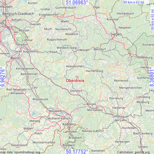
Oberdreis GPS coordinates[2]
50° 37' 32.484" North, 7° 39' 57.204" East
| Map corner | latitude | longitude |
|---|---|---|
| Upper-left | 51.06963°, | 6.96276° |
| Center: | 50.62569°, | 7.66589° |
| Lower-right: | 50.17752°, | 8.36901° |
| Map W x H: | 99.2×99.2 km | = 61.6×61.6mi |
| max Lat: | 55.01917° ⇑49.8% North |
| Oberdreis: | 50.62569° |
| min Lat: | ⇓50.2% South 47.40724° |
| min Long | Oberdreis | max Long |
| 5.92978° | 7.66589° | 14.98853° |
| W 16.3%⇐ | ⇒83.7% E |
Elevation
Elevation of Oberdreis is 286 m = 938 ft, and this is 36.9 m = 121 ft above average elevation for this country.
| Max E: |
1256 m = 4121 ft | 40.6% |
| Oberdreis | 286 m 938 ft | |
| Avg. | 249.1 m = 817 ft | |
Min E: |
-5 m = -16 ft | 59.4% |
See also: Germany elevation on elevation.city.
Geographical zone
Oberdreis is located in North temperate zone (between Tropic of Cancer and the Arctic Circle). Distance of this North polar circle is 1772.1 km =1101.1 mi to North.| Distance of | km | miles | from Oberdreis |
|---|---|---|---|
| North Pole | 4378 | 2720.4 | to North |
| Arctic Circle | 1772.1 | 1101.1 | to North |
| Tropic Cancer | 3023.1 | 1878.5 | to South |
| Equator | 5629 | 3497.7 | to South |


Nearby cities:
15 places around Oberdreis: (largest is in red/bold)
• Berod bei Höchstenbach
3.1 km =1.9 mi,  37°
37°
• Fluterschen
5.3 km =3.3 mi,  328°
328°
• Gieleroth
4.7 km =2.9 mi,  15°
15°
• Hanroth
4.8 km =3 mi,  193°
193°
• Mündersbach
5.3 km =3.3 mi,  114°
114°
• Niederwambach
4.7 km =2.9 mi,  280°
280°
• Oberwambach
4.7 km =2.9 mi,  346°
346°
• Puderbach
4.5 km =2.8 mi,  230°
230°
• Ratzert
4.4 km =2.7 mi,  307°
307°
• Roßbach
2.6 km =1.6 mi,  153°
153°
• Steimel
2.5 km =1.6 mi,  246°
246°
• Stürzelbach
4.4 km =2.7 mi, 307°
• Wahlrod
4.5 km =2.8 mi,  52°
52°
• Welkenbach
4.4 km =2.7 mi,  78°
78°
• Woldert
3.1 km =1.9 mi,  201°
201°
Sources, notices
• [Note1] Compared only with cities in Germany existing in our database
• [Src1] Map data: © OpenStreetMap contributors (CC-BY-SA)
• [Src2] Other city data from geonames.org with taken over terms of usage.
• [Src3] Geographical zone / Annual Mean Temperature by Robert A. Rohde @ Wikipedia
