Roßbach geodata
Roßbach (Rheinland-Pfalz) is a seat of a fourth-order administrative division; located in Germany in Europe/Berlin (GMT+2) time zone. In our database, there are 11009 cities with bigger population. Compared to other cities in Germany, 50.4% of cities are located further ↑North; 83.4% of cities are located further →East and 61.3% of cities have lower elevation than Roßbach. Note1


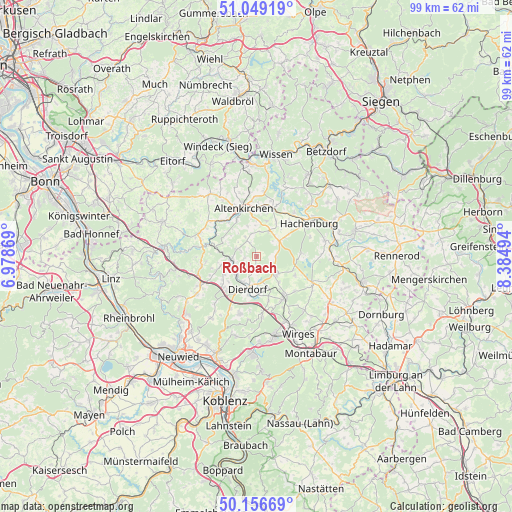
Roßbach GPS coordinates[2]
50° 36' 18.216" North, 7° 40' 54.552" East
| Map corner | latitude | longitude |
|---|---|---|
| Upper-left | 51.04919°, | 6.97869° |
| Center: | 50.60506°, | 7.68182° |
| Lower-right: | 50.15669°, | 8.38494° |
| Map W x H: | 99.2×99.2 km | = 61.6×61.6mi |
| max Lat: | 55.01917° ⇑50.4% North |
| Roßbach: | 50.60506° |
| min Lat: | ⇓49.6% South 47.40724° |
| min Long | Roßbach | max Long |
| 5.92978° | 7.68182° | 14.98853° |
| W 16.6%⇐ | ⇒83.4% E |
Elevation
Elevation of Roßbach is 298 m = 978 ft, and this is 48.9 m = 160 ft above average elevation for this country.
| Max E: |
1256 m = 4121 ft | 38.7% |
| Roßbach | 298 m 978 ft | |
| Avg. | 249.1 m = 817 ft | |
Min E: |
-5 m = -16 ft | 61.3% |
See also: Germany elevation on elevation.city.
Geographical zone
Roßbach is located in North temperate zone (between Tropic of Cancer and the Arctic Circle). Distance of this North polar circle is 1774.4 km =1102.6 mi to North.| Distance of | km | miles | from Roßbach |
|---|---|---|---|
| North Pole | 4380.3 | 2721.8 | to North |
| Arctic Circle | 1774.4 | 1102.6 | to North |
| Tropic Cancer | 3020.8 | 1877 | to South |
| Equator | 5626.8 | 3496.3 | to South |


Nearby cities:
15 places around Roßbach: (largest is in red/bold)
• Berod bei Höchstenbach
4.8 km =3 mi,  9°
9°
• Freirachdorf
3.4 km =2.1 mi,  134°
134°
• Hanroth
3.3 km =2.1 mi,  222°
222°
• Herschbach
4.4 km =2.7 mi,  123°
123°
• Höchstenbach
5.5 km =3.4 mi,  54°
54°
• Marienhausen
4.6 km =2.9 mi,  170°
170°
• Maroth
3.1 km =1.9 mi, 169°
• Mündersbach
3.7 km =2.3 mi,  87°
87°
• Oberdreis
2.6 km =1.6 mi,  333°
333°
• Puderbach
4.6 km =2.9 mi,  263°
263°
• Raubach
5.2 km =3.2 mi,  230°
230°
• Steimel
3.7 km =2.3 mi,  290°
290°
• Wahlrod
5.6 km =3.5 mi,  26°
26°
• Welkenbach
4.4 km =2.7 mi, 45°
• Woldert
2.3 km =1.4 mi, 255°
Sources, notices
• [Note1] Compared only with cities in Germany existing in our database
• [Src1] Map data: © OpenStreetMap contributors (CC-BY-SA)
• [Src2] Other city data from geonames.org with taken over terms of usage.
• [Src3] Geographical zone / Annual Mean Temperature by Robert A. Rohde @ Wikipedia
