Preetz geodata
Preetz (Mecklenburg-Vorpommern) is a populated place; located in Germany in Europe/Berlin (GMT+2) time zone. With population of 1,021 people, there are 7109 cities with bigger population in this country. Compared to other cities in Germany, 96.9% of cities are located further ↓South; 92.3% of cities are located further ←West and 94.3% of cities have higher elevation than Preetz. Note1
Administrative division(s):
- Level 1: Mecklenburg-Vorpommern
- Level 3: Vorpommern-Rügen
- Level 4: Preetz


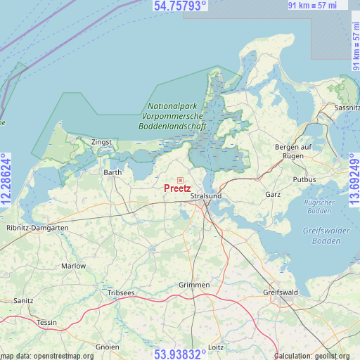
Preetz GPS coordinates[2]
54° 21' 0.612" North, 12° 59' 21.696" East
| Map corner | latitude | longitude |
|---|---|---|
| Upper-left | 54.75793°, | 12.28624° |
| Center: | 54.35017°, | 12.98936° |
| Lower-right: | 53.93832°, | 13.69249° |
| Map W x H: | 91.1×91.1 km | = 56.6×56.6mi |
| max Lat: | 55.01917° ⇑3.1% North |
| Preetz: | 54.35017° |
| min Lat: | ⇓96.9% South 47.40724° |
| min Long | Preetz | max Long |
| 5.92978° | 12.98936° | 14.98853° |
| W 92.3%⇐ | ⇒7.7% E |
Elevation
Elevation of Preetz is 10 m = 33 ft, and this is 239.1 m = 784 ft below average elevation for this country.
| Max E: |
1256 m = 4121 ft | 94.3% |
| Avg. | 249.1 m = 817 ft | |
| Preetz | 10 m = 33 ft | |
Min E: |
-5 m = -16 ft | 5.7% |
See also: Germany elevation on elevation.city.
Geographical zone
Preetz is located in North temperate zone (between Tropic of Cancer and the Arctic Circle). Distance of this North polar circle is 1358 km =843.8 mi to North.| Distance of | km | miles | from Preetz |
|---|---|---|---|
| North Pole | 3963.9 | 2463.1 | to North |
| Arctic Circle | 1358 | 843.8 | to North |
| Tropic Cancer | 3437.3 | 2135.8 | to South |
| Equator | 6043.2 | 3755.1 | to South |


Nearby cities:
15 places around Preetz: (largest is in red/bold)
• Altefähr
9.2 km =5.7 mi,  104°
104°
• Altenpleen
2.2 km =1.4 mi,  282°
282°
• Groß Mohrdorf
5 km =3.1 mi,  327°
327°
• Jakobsdorf
13.5 km =8.4 mi,  196°
196°
• Klausdorf
6.2 km =3.9 mi,  14°
14°
• Kramerhof
4.2 km =2.6 mi,  84°
84°
• Lüssow
8.1 km =5 mi,  160°
160°
• Niepars
5.8 km =3.6 mi,  226°
226°
• Pantelitz
5.6 km =3.5 mi,  193°
193°
• Prohn
3.1 km =1.9 mi,  46°
46°
• Rambin
14 km =8.7 mi,  87°
87°
• Steinhagen
13.8 km =8.6 mi,  180°
180°
• Stralsund
7.5 km =4.7 mi,  127°
127°
• Wendorf
12 km =7.5 mi,  151°
151°
• Zarrendorf
14.5 km =9 mi, 150°
Sources, notices
• [Note1] Compared only with cities in Germany existing in our database
• [Src1] Map data: © OpenStreetMap contributors (CC-BY-SA)
• [Src2] Other city data from geonames.org with taken over terms of usage.
• [Src3] Geographical zone / Annual Mean Temperature by Robert A. Rohde @ Wikipedia
