Altefähr geodata
Altefähr (Mecklenburg-Vorpommern) is a populated place; located in Germany in Europe/Berlin (GMT+2) time zone. With population of 1,301 people, there are 6303 cities with bigger population in this country. Compared to other cities in Germany, 96.6% of cities are located further ↓South; 93.2% of cities are located further ←West and 92.7% of cities have higher elevation than Altefähr. Note1
Administrative division(s):
- Level 1: Mecklenburg-Vorpommern
- Level 3: Vorpommern-Rügen
- Level 4: Altefähr


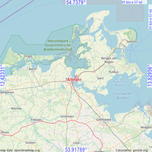
Altefähr GPS coordinates[2]
54° 19' 47.784" North, 13° 7' 35.148" East
| Map corner | latitude | longitude |
|---|---|---|
| Upper-left | 54.7379°, | 12.42331° |
| Center: | 54.32994°, | 13.12643° |
| Lower-right: | 53.91789°, | 13.82956° |
| Map W x H: | 91.2×91.2 km | = 56.7×56.7mi |
| max Lat: | 55.01917° ⇑3.4% North |
| Altefähr: | 54.32994° |
| min Lat: | ⇓96.6% South 47.40724° |
| min Long | Altefähr | max Long |
| 5.92978° | 13.12643° | 14.98853° |
| W 93.2%⇐ | ⇒6.8% E |
Elevation
Elevation of Altefähr is 14 m = 46 ft, and this is 235.1 m = 771 ft below average elevation for this country.
| Max E: |
1256 m = 4121 ft | 92.7% |
| Avg. | 249.1 m = 817 ft | |
| Altefähr | 14 m = 46 ft | |
Min E: |
-5 m = -16 ft | 7.3% |
See also: Germany elevation on elevation.city.
Geographical zone
Altefähr is located in North temperate zone (between Tropic of Cancer and the Arctic Circle). Distance of this North polar circle is 1360.3 km =845.3 mi to North.| Distance of | km | miles | from Altefähr |
|---|---|---|---|
| North Pole | 3966.1 | 2464.4 | to North |
| Arctic Circle | 1360.3 | 845.3 | to North |
| Tropic Cancer | 3435 | 2134.4 | to South |
| Equator | 6040.9 | 3753.6 | to South |


Nearby cities:
15 places around Altefähr: (largest is in red/bold)
• Altenpleen
11.4 km =7.1 mi,  283°
283°
• Brandshagen
10.4 km =6.5 mi,  164°
164°
• Klausdorf
11 km =6.8 mi,  318°
318°
• Kramerhof
5.4 km =3.4 mi,  299°
299°
• Lüssow
8.2 km =5.1 mi,  229°
229°
• Niepars
13.2 km =8.2 mi,  262°
262°
• Pantelitz
10.7 km =6.6 mi,  252°
252°
• Poseritz
10.3 km =6.4 mi,  110°
110°
• Preetz
9.2 km =5.7 mi, 284°
• Prohn
8 km =5 mi, 303°
• Rambin
5.8 km =3.6 mi,  60°
60°
• Samtens
11.2 km =7 mi,  75°
75°
• Stralsund
3.7 km =2.3 mi, 231°
• Wendorf
8.9 km =5.5 mi,  201°
201°
• Zarrendorf
10.5 km =6.5 mi,  189°
189°
Sources, notices
• [Note1] Compared only with cities in Germany existing in our database
• [Src1] Map data: © OpenStreetMap contributors (CC-BY-SA)
• [Src2] Other city data from geonames.org with taken over terms of usage.
• [Src3] Geographical zone / Annual Mean Temperature by Robert A. Rohde @ Wikipedia
